😱 Are We on the Brink of a Major Earthquake? California’s 200 Quakes and Chile’s 65% Chance of Catastrophe! 😱
Right now, something mysterious is happening beneath California, and no one can fully explain why.
In the past two weeks, more than 200 earthquakes have rattled the ground from San Francisco to San Diego.
This is not mere random noise; it is a pattern that began accelerating on February 2, 2026.
But that’s only part of the story.
Across the Pacific, scientists in Chile have issued a startling forecast: there is a 65% probability of a magnitude 8 earthquake striking their coast this year.
The question arises: why are two of the most seismically dangerous regions on Earth waking up at the same time?
What hidden forces connect California’s trembling suburbs to the violent potential buried beneath South America?
And what happens if both systems release their energy simultaneously?
The answers lie buried deep beneath the surface, but the danger is rising.
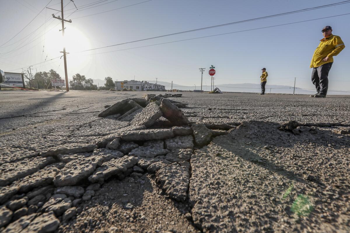
Just before dawn on February 2, 2026, the ground beneath San Ramon began to shake.
At 6:27 a.m. local time, a magnitude 3.8 earthquake struck this quiet suburb nestled in California’s East Bay.
Most residents felt only a gentle roll beneath their beds, but this was merely the first warning.
Thirty-four minutes later, a magnitude 4.2 earthquake followed, strong enough to rattle windows in San Francisco, 40 miles away.
Items tumbled from shelves, and dogs began barking across entire neighborhoods.

By noon, the United States Geological Survey (USGS) had recorded 52 earthquakes in the same narrow zone, with 37 of those tremors exceeding magnitude 2.0.
The pace was relentless; new shocks arrived every few minutes, each one a reminder that the earth beneath San Ramon refused to settle.
Within hours, more than 4,000 people submitted reports to the USGS confirming they felt the shaking.
The tremors spread outward through Oakland, Richmond, San Leandro, and into San Francisco’s Glen Park District.
Regional transit systems slowed their trains for safety inspections, and commuters faced delays as officials ensured the tracks remained intact.
What came next shocked even the scientists.
The shaking did not stop by nightfall; instead, the sequence continued into the following day and the day after that.
This was no ordinary earthquake; it was a swarm.
Unlike traditional seismic events, an earthquake swarm has no single dominant shock followed by diminishing aftershocks.
Instead, it produces wave after wave of moderate tremors over days or weeks without any clear peak.
The energy builds and releases repeatedly as if the fault itself is stuttering, unable to decide whether to slip or hold.
This behavior had haunted San Ramon before.
The current swarm began not on February 2, but three months earlier on November 9, 2025.
Since that date, 91 earthquakes above magnitude 2.0 had already shaken the region.
After January 10, the swarm fell silent, and scientists began to hope the episode had ended.
Then February 2 arrived, and the silence shattered.
The fault was not finished; it had only been gathering strength.
San Ramon sits directly atop the Calaveras Fault, a major branch of the greater San Andreas fault system.
The Calaveras extends more than 90 miles through Northern California, threading beneath suburbs, golf courses, and highways as it carries stress from the Pacific plate’s relentless grind against North America.
The fault branches away from the San Andreas near Hollister and runs northward through the Diablo Range until it terminates near Danville, just a few miles from San Ramon.
This branching structure creates a complex network of fractures beneath the valley floor.
Geologists describe it as a zone of cracks, weakened rock, and fluid pathways that allow seismic energy to migrate unpredictably.
Where faults branch, stress concentrates.
The Calaveras has produced damaging earthquakes before; a magnitude 6.2 struck Morgan Hill in 1984, and another magnitude 6.5 shook the region in 1911.
The fault moves slowly, creeping at roughly 7 millimeters per year, but it does not always release that energy smoothly.
Recent research from UC Berkeley suggests that the Calaveras and Hayward faults may connect deep beneath the surface, potentially forming a single continuous structure capable of rupturing together.
If this connection proves accurate, it could dramatically increase the potential magnitude of future earthquakes along both faults.
But the swarm beneath San Ramon was only the beginning.
Six hundred miles to the south, another swarm was awakening.
On the evening of January 19, 2026, a magnitude 4.9 earthquake struck the Coachella Valley, 12 miles northeast of Indio.

The shaking radiated across a vast swath of Southern California, reaching communities from Los Angeles to San Diego.
More than 8,000 people reported feeling the tremor to the USGS.
What followed was a rapid escalation.
Within 24 hours, more than 50 aftershocks rippled through the desert, with 14 strong enough to be felt by residents.
The USGS reported that the epicenter lay along the Mission Creek strand of the San Andreas fault, a segment known for frequent seismic activity and regarded as part of the major plate boundary structure that defines California’s geology.
The shaking continued for days.
Over 250 aftershocks were eventually recorded, and scientists warned that a 5% chance existed that the initial shock could be a foreshock, a precursor to something larger.
The ground had one more secret for residents living near Dublin, less than 10 miles from the swarm’s epicenter.
The morning of February 2 began like any other, with coffee brewing and routines unfolding.
Then the first tremor arrived.
Walls shuddered across the neighborhood, picture frames slid from hooks, and cats bolted beneath furniture.
Then a second quake struck, stronger this time, sending mugs sliding across countertops.
People stood frozen in kitchens across the East Bay, listening to the silence between the shocks and waiting for the next one to arrive.
It came minutes later, then again, and again.
By noon, many had lost count.

Neighbors knocked on doors, eyes wide, asking if they should evacuate.
No one had answers.
They had lived in California their whole lives and felt earthquakes before, but nothing like this—nothing that refused to end.
On January 15, 2026, scientists published a discovery that rewrote the map of California’s seismic hazards.
A study in the journal Science revealed the existence of the Pioneer Fragment, a remnant of an ancient tectonic plate that had been lost for 30 million years.
The fragment lies buried beneath the Mendocino Triple Junction, where California’s San Andreas Fault meets the Cascadia Subduction Zone.
Researchers from the USGS, UC Davis, and the University of Colorado Boulder detected the fragment using swarms of tiny low-frequency earthquakes occurring deep beneath the Earth’s surface.
The discovery was profound.
The Pioneer Fragment is being dragged northwest beneath the North American plate by the Pacific plate’s motion.
This increases the area of contact between what is effectively the Pacific plate and the Cascadia Subduction Zone.
More contact could mean more friction, which implies greater stress accumulation and, in theory, heightens rupture risk.
USGS geophysicist David Shel explained that the fragment creates a hidden fault boundary not currently included in seismic hazard models.
Whether this fault could generate large earthquakes remains uncertain, but the tectonic picture beneath Northern California is far more complex than previously understood.
The Cascadia Subduction Zone is one of the most dangerous fault systems on Earth, stretching from Vancouver Island to Northern California and spanning over 600 miles of coastline.
Scientists estimate it is capable of producing earthquakes of magnitude 9 or higher—events that release a thousand times more energy than a magnitude 7 shock.
The last full rupture of the Cascadia occurred on January 26, 1700, generating a mᴀssive tsunami that devastated the Pacific Northwest and reached Japan’s coast 15 hours later.
Indigenous oral histories describe the catastrophe as a night when the ground shook for minutes and the sea withdrew before returning with overwhelming force.
But the Cascadia does not act alone.
Recent research from Oregon State University suggests that large earthquakes on the Cascadia Subduction Zone may trigger earthquakes on the northern San Andreas Fault.
Sediment cores from submarine canyons off the California coast show paired turbidite deposits—evidence that both fault systems appear to have ruptured in close succession repeatedly over the past 3,000 years.
If this interpretation holds, the geological domino effect could be real.
Based on the sediment record, when Cascadia breaks, the San Andreas may follow within hours, days, or even decades.
The exact timing and precise mechanism of triggering remain subjects of ongoing scientific debate.
Now, the focus shifts across the Pacific to a coastline that has experienced the most powerful earthquake in recorded history.
Chile sits atop the collision zone between the Nazca Plate and the South American Plate.
The Nazca dives beneath the continent at a rate of roughly 7 centimeters per year, building immense stress along a subduction zone that stretches thousands of miles.
When that stress releases, the results are catastrophic.
The National Seismological Center of Chile has issued a stark warning: according to director Sergio Barrientos, there is a 65% probability that a magnitude 8 or larger earthquake will strike Chile in 2026.
This forecast is based on historical recurrence intervals.
Statistical analyses suggest Chile experiences a major earthquake of this scale roughly every 10 to 12 years.

The last great shock arrived in 2015 when a magnitude 8.4 earthquake struck off the coast of Iquique, generating a tsunami and killing more than a dozen people.
Before that, the magnitude 8.8 earthquake in 2010 claimed over 500 lives and left 2 million homeless.
Chile’s documented seismic history stretches back centuries, and the pattern is clear.
The question is not whether another mᴀssive earthquake will strike, but when.
On May 22, 1960, the most powerful earthquake ever recorded shook southern Chile.
The magnitude 9.5 Valdivia earthquake released energy equivalent to 20,000 Hiroshima bombs, with a rupture zone extending nearly 1,000 kilometers along the coast.
Local tsunamis with waves reaching 25 meters devastated coastal villages.
The main tsunami traveled across the Pacific Ocean, killing 61 people in Hawaii 15 hours later, 139 in Japan, and 21 in the Philippines.
The combined death toll ranged into the thousands, and 2 million Chileans became homeless.
The earthquake also triggered volcanic eruptions and landslides that reshaped the landscape, creating lakes where rivers once flowed and causing entire towns to subside beneath the waves.
This is what a magnitude 9 earthquake can do.
This is the destructive potential of the Cascadia Subduction Zone and the Chile Subduction Zone.
Despite decades of research, no scientist can predict exactly when or where the next major earthquake will strike.
The physics of fault rupture remain partially understood.
Stress accumulates invisibly, and faults can remain locked for centuries before releasing their energy in seconds.
What scientists can do is calculate probabilities, recognize patterns, and analyze plate motion.
They can identify fault segments under high stress and estimate recurrence intervals based on geological evidence.
But a probability is not a prediction; it is a warning.
California’s Shake Alert system represents one of the most advanced earthquake early warning networks on Earth.
Managed by the USGS, Shake Alert uses more than 1,500 seismometers across the West Coast to detect earthquakes within seconds of their occurrence.
Alerts can reach cell phones before destructive shaking arrives, providing precious seconds to drop, cover, and hold on.
Chile maintains its own tsunami warning networks, tested repeatedly by the country’s violent seismic history.
These systems save lives, but they cannot prevent the earthquake itself.
Earthquake swarms are common in active zones, and most do not lead to larger earthquakes.
San Ramon has experienced similar sequences before, and they ended without catastrophe.
This is the most likely outcome again, but “most likely” is not certain.

The swarms in San Ramon and Coachella Valley have not stopped.
Scientists continue to record dozens of small earthquakes each week along California’s major fault systems.
The discovery of the Pioneer Fragment has revealed hidden complexity beneath the Mendocino Triple Junction, adding potential hazards to an already dangerous region.
Evidence suggests that the Cascadia Subduction Zone and the San Andreas Fault may be linked, potentially capable of triggering one another in rapid succession.
Across the Pacific, Chile’s seismologists have issued their warning: a 65% chance of a magnitude 8 earthquake in 2026.
The Nazca Plate continues its relentless dive beneath South America, building stress that will eventually release.
What remains unknown is the timing.
Will the next great earthquake arrive in weeks, months, or decades?
Will it strike California, Chile, or both?
And if the Cascadia ruptures, will the San Andreas follow?
The ground beneath our feet is never truly still.
It is always moving, always storing energy, always waiting.


