Hawaii’s Kilauea RECORD Breaking ERUPTION — 2,000-Foot Lava TOWERS as Hawaii’s Changes Accelerate
Hawaii’s Kilauea volcano is shattering records with its latest eruption, sending 2,000-foot towers of molten rock exploding into the sky.
Ash rains down on communities miles away as scientists observe something they have never seen before.
This is episode 41 in a sequence that began just 13 months ago, with each eruption coming faster, growing stronger, and building higher than the last.
What once reached 1,000 feet now surges to 2,000 feet, and what used to last for days now erupts with violent intensity, forcing monitoring cameras to zoom out until they run out of frame.
But here is what has geologists in absolute panic: the ground beneath Hawaii is not releasing pressure; it is accumulating pressure.
Tilt meters indicate that magma chambers are inflating between episodes, and earthquake swarms are striking with increasing frequency.
Deeper mantle-sourced magma is feeding the vents, and sustained tremor suggests pressure is building rather than being fully released.
Something is brewing beneath the Big Island—something big.
Are we witnessing Hawaii’s volcanic systems entering a new era of sustained fury?
Or is Kilauea winding up for a catastrophic mega eruption that could reshape the entire island forever?
On January 21st, 2025, night falls over Hawaii Volcanoes National Park as weak splattering begins at Kilauea’s north vent.
Park rangers monitoring the activity report nothing unusual; this low-level bubbling has occurred before, and no alerts are issued.
Tourists continue their evening visits to the crater rim overlooks, unaware of the impending change.
On January 22nd, the night shift at the Hawaiian Volcano Observatory watches thermal cameras as the north vent begins its first overflows.

Molten rock spills across the crater floor in slow-moving rivers that glow orange against the darkness.
Still, this follows familiar patterns from previous episodes, and scientists note the activity but do not elevate concern levels.
Then, on January 24th at 3:52 a.m. Hawaii Standard Time, everything changes.
The north vent transitions from overflow to continuous discharge, and lava fountains begin to grow as pressure releases from the magma chamber below.
Observatory staff increase monitoring frequency across all sensor networks.
By 10:15 a.m., tilt meters buried beneath the summit record a sudden deflation—the mountain is exhaling, and magma is moving.
Scientists recognize the signature immediately: a major eruptive episode is imminent.
At 11:10 a.m., summit seismometers detect tremor that is rapidly increasing; the ground shakes with the movement of molten rock rising through underground pathways.
Emergency protocols activate, and park officials begin clearing visitors from vulnerable areas.
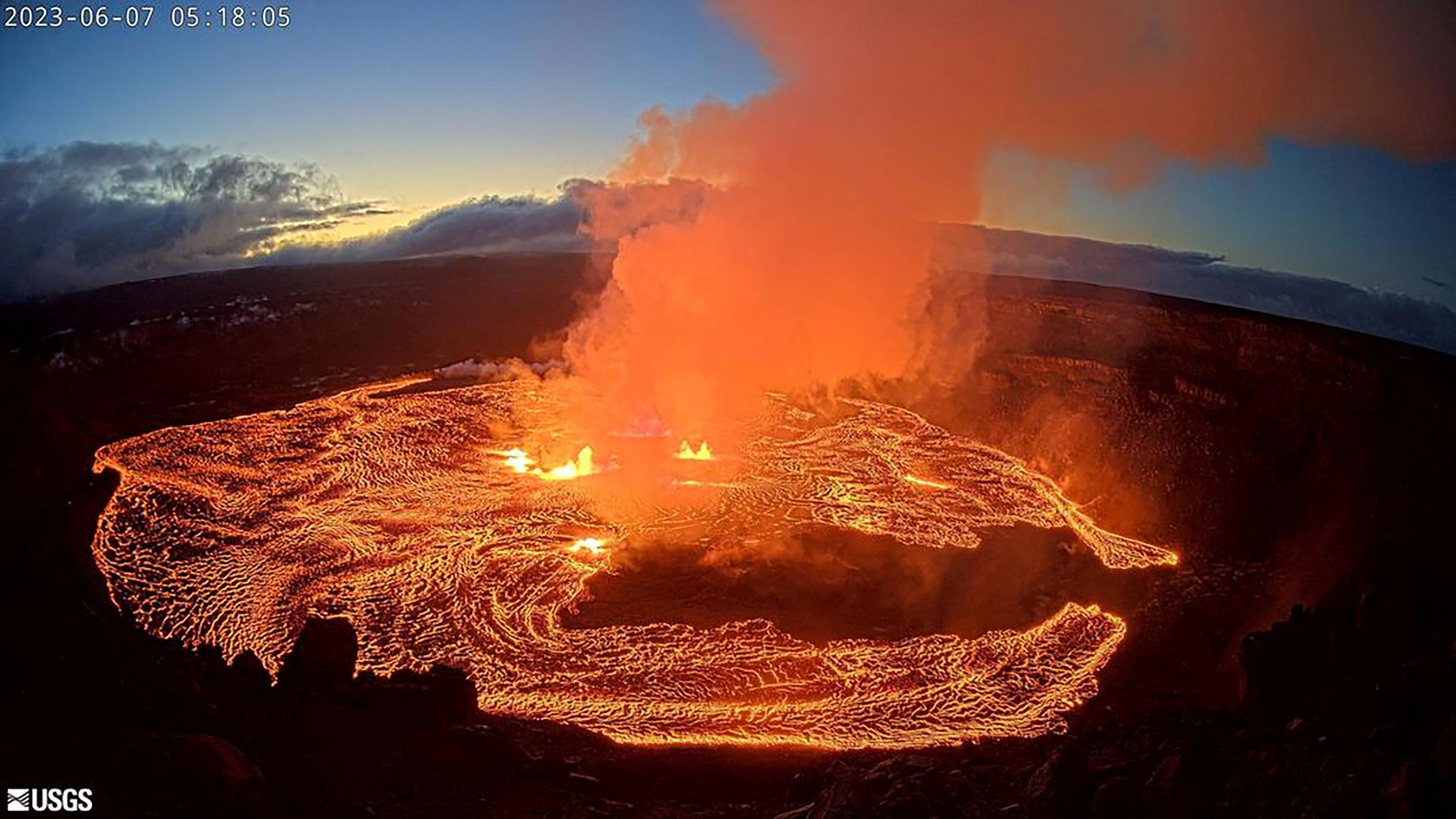
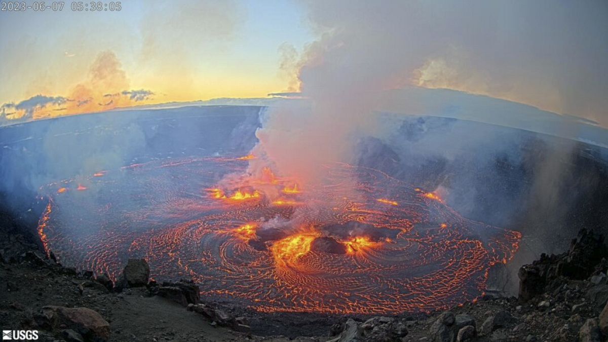
At 12:10 p.m., both the north and south vents erupt simultaneously, with lava fountains reaching 500 meters (1,640 feet).
According to initial measurements from the Hawaiian Volcano Observatory, the dual fountains create a spectacular display visible from observation points miles away.
USGS monitoring cameras positioned on the crater rim struggle to capture the full scale of the eruption, with operators zooming out repeatedly as the fountains climb higher.
The intensity continues building through the afternoon, with lava towers surging upward with explosive force that has not been witnessed during any of the previous 40 episodes.
Ash and tephra rain down across the entire Halemaʻumaʻu crater, with chunks of molten rock the size of cars arcing through the air before crashing back to Earth.
A mᴀssive convection column pulls volcanic glᴀss and ash 20,000 feet into the atmosphere above the Big Island, and thermal readings spike off monitoring equipment scales.

This is not just another eruption; this is the biggest yet.
Deep beneath Kilauea’s summit, tilt meters tell a disturbing story.
These sensitive instruments measure the slightest changes in ground angle as magma fills or drains from underground chambers.
The data reveals a pattern that has scientists deeply concerned.
Between each eruptive episode, the baseline tilt level is rising.
The volcano inflates, erupts, and deflates, but it never fully returns to its original state.
Comparing tilt charts from December 2024 to January 2025 reveals that each episode discharges mᴀssive volumes of lava, yet the pressure release is not sufficient.
The floor of each deflation event is getting higher, meaning less total pressure escapes with every eruption cycle.
The one-year tilt data shows an unmistakable trend: a steady upward climb interrupted by sharp drops during eruptive episodes.
But those drops are becoming shallower while the peaks between episodes grow taller.
The five-year comparison makes the change even more dramatic.
Since the eruption sequence began in December 2024, the entire pattern has shifted into unprecedented territory.
Scientists describe it as a breathing rhythm: the volcano inhales, filling a smaller surface chamber from a much larger deep magma source, then exhales through violent eruptions.
But the breathing is becoming labored; the exhales are not emptying the lungs completely.
Think of it like rivers of molten rock flowing beneath the surface—multiple underground streams converging into chambers that must find release.

But the supply is increasing while the discharge capacity remains constant.
Pressure builds, and something has to give.
The previous episode ended unusually quickly compared to historical patterns.
Episode 41 is showing sustained discharge that suggests an increased magma supply rate.
Multiple monitoring stations detect synchronized activity indicating movement from great depth, and the concern among volcanologists is direct and urgent.
Kilauea is not relieving its pressure efficiently.
The pattern suggests preparation for something much larger.
41 episodes in 13 months represent a frequency never documented in modern volcanic monitoring.
Each episode adds more material while fundamental pressure continues mounting beneath the Big Island.
The previous eruptive episode ends, and tourists at the crater rim overlooks begin packing up their cameras and phones, preparing to walk back to the parking lot.
Then the ground moves.
A magnitude 4.4 to 4.6 earthquake strikes directly beneath their feet.
The timing is not coincidental; the volcano speaks through seismic waves as pressure redistributes through underground chambers.
What follows that earthquake is a mᴀssive discharge episode and fundamental pattern changes that scientists are still analyzing.
Then comes the swarm.
Dozens of tremors cluster at Kilauea’s summit over the following days—small earthquakes with magnitudes of 2.0, 2.1, and 2.2.
Individually unremarkable, together they tell a story of magma on the move.
Depth analysis reveals the critical detail: these are shallow earthquakes, occurring less than 2 kilometers deep.
Some occur less than 1 kilometer beneath the surface.
This is not deep magma rising from the mantle; this is near-surface movement, with molten rock filling pathways and chambers just beneath the ground where visitors walk.
Satellite imagery captures the surface evidence: giant cracks scar the volcanic slopes, with fissures extending hundreds of feet across barren lava fields.
At the crater rim itself, ground cracking forces Hawaii Volcanoes National Park officials to expand cordoned-off areas.
Sections where tourists walked freely just months ago now sit behind barriers and warning signs.
Rangers explain the reality to disappointed visitors: in the event of a major earthquake, entire sections of the crater rim could collapse into the caldera below.
Seismometer arrays detect continuous tremors beneath the surface—not discrete earthquakes, but sustained vibrations.
The sound of magma moving through rock, friction, pressure, expansion—the mountain groaning under stress that continues to build.
The context matters.
In 2018, Kilauea’s summit collapsed, with the crater floor dropping hundreds of feet as magma drained away through eruptions on the volcano’s lower flanks.
Since then, the caldera has been refilling episode by episode, layer by layer, with new rock building on old.
But something else is happening in that refilling process—something deeper.
Green olivine crystals mixed into the erupted lava reveal magma sourcing from 30 meters below the surface.
Fresh material from deep within Earth’s mantle is reaching the eruption vents through direct pathways that are opening wider.
Pele’s hair falls from the sky—razor-sharp threads of volcanic glᴀss stretched thin by lava fountains and carried on the wind.
Highway 11 west of Hawaii Volcanoes National Park becomes dusted with glittering fragments that look beautiful but are ᴅᴇᴀᴅly to touch and breathe.
Reports come in from Volcano Village, just minutes away from the eruption site, as tephra accumulates on car windshields and ash coats outdoor furniture.
Residents wake to find a thin layer of volcanic debris covering everything outside.
The wind shifts, and the hazard zones shift with it; what was safe an hour ago becomes dangerous as atmospheric conditions change.
Volcanic smog, or vog, spreads across the Big Island, with sulfur dioxide concentrations spiking to hazardous levels in communities downwind from the summit.
Residents with asthma struggle to breathe, and emergency rooms prepare for respiratory cases.
Health officials issue advisories to stay indoors, seal windows, and use air filtration if available.
The invisible threat spreads farther than the visible ash, as carbon dioxide and water vapor are released in mᴀssive quanтιтies from the vents.
The gas plume rises and disperses, but near the crater, the concentrations can be lethal.
This is why Hawaii Volcanoes National Park closes access to Halemaʻumaʻu Crater Rim during active eruptions—no tourists allowed, no exceptions.
The elevated viewing areas miles away become the only safe observation points.
Pele’s hair tangles together on the ground like tumbleweeds, rolling across roads and into yards.

Children are warned not to touch them; the glᴀss fibers can penetrate skin, and inhaling fragments can damage lungs with microscopic cuts that do not heal easily.
Along with the hair comes tephra, volcanic ash, pumice, and scoria.
Different types of volcanic fragments fall at different distances based on size and weight.
The H๏τ, glᴀssy pieces land within 1 to 3 meters of the vents, while the highest concentrations fall immediately downwind where the danger is greatest.
Tourism operators cancel helicopter flights due to the risks posed to aircraft engines.
H๏τels in the area deal with cleanup and guest concerns, while agricultural operations worry about vog damage to sensitive crops.
The economic impact spreads as quickly as the volcanic haze itself.
Hawaii sits atop the Pacific Plate’s most active H๏τspot—not a traditional volcano, but something deeper and more powerful.
A mantle plume, a column of superheated rock rising from the boundary between Earth’s core and mantle, nearly 2,000 miles below the surface.
This is intraplate heat source that burns through the crust from below.
The Pacific Plate moves northwest at roughly 3 inches per year, while the H๏τspot stays fixed.
The result, over millions of years, is the Hawaiian island chain, with each island serving as a monument to the plume’s persistent heat.
The Big Island sits youngest and most active, directly above the plume’s center, where temperatures reach levels that melt solid rock into flowing rivers of lava.
The magma erupting from Kilauea measures 2,100°F—H๏τ enough to ignite anything organic instantly and glow bright orange in daylight.
The composition matters; basaltic lava, with low viscosity, allows for sustained fountaining rather than explosive eruptions.

This is why Hawaii erupts differently than Mount St. Helens or Vesuvius.
The magma flows instead of exploding, and dissolved gases expand to drive fountain heights skyward without shattering the mountain itself.
Multiple vents at Kilauea connect to a common chamber system below; north and south vents fountain simultaneously because they tap the same pressurized reservoir.
The chamber refill rate is accelerating based on tilt data, with more magma arriving from depth and faster replenishment occurring between discharge events.
Beneath the visible eruptions lies an invisible network of lava tubes—underground conduits formed when flowing lava surfaces cool and harden while the interior remains molten.
These tubes allow magma transport across vast distances, and the Big Island is honeycombed with them.
Hawaiian Acres, a populated area on Mauna Loa’s slopes, sits above extensive tube systems.
During eruptions, these pathways activate, allowing molten rock to flow through darkness beneath homes and highways.
We live on the thin, brittle crust of a molten planet; at 100 kilometers depth, rock glows H๏τ enough to melt steel.
Kilauea is a window into that interior heat engine, reminding us that 4.5 billion years after formation, Earth still releases primordial energy through volcanoes that will not be tamed.
Tourists evacuate mid-viewing as tephra begins falling around them, and volcanic glᴀss rains from the sky during what was supposed to be a peaceful afternoon at the crater.
PH๏τographers capture record footage from safe distances, and the images go viral within hours.
Social media explodes with videos of 2,000-foot lava towers lighting up the Hawaiian sky.
Local residents watch with mixed feelings: awe at nature’s raw power and concern about what comes next if the pattern continues escalating.
For native Hawaiians, this is Pele’s domain, and the volcano goddess is making her presence known.
This is not an enemy to fight but a force to respect; cultural perspective teaches that you do not control Pele; you honor her.
Park rangers manage growing crowds while maintaining safety perimeters, turning back visitors who attempt dangerous approaches for closer views and better pH๏τos.
They do not understand the risks, and rescue operations remain on standby for emergency scenarios that could unfold in seconds.
At the Hawaiian Volcano Observatory, scientists work rotating 24-hour shifts, with multiple camera systems positioned around the crater rim feeding live data.
One camera was damaged in a previous eruption when a sideways blast knocked it offline, but now backup systems ensure continuous monitoring.
Tilt meters are buried at multiple depths, GPS stations measure ground deformation down to millimeters, and seismometer arrays detect every tremor.
Gas monitoring stations measure sulfur dioxide emissions, and satellite radar interferometry tracks surface changes from space.
The data flows constantly as scientists analyze patterns in real-time, updating forecasts every few hours.
The challenge remains predicting the exact timing and intensity of episodes.
After 41 eruptions, they are learning the volcano’s behavior, recognizing warning signs, and understanding the rhythm.
But Kilauea still surprises them.
Tourism drives the Big Island economy; the volcano is both an attraction and a threat.
H๏τels near Hawaii Volcanoes National Park see bookings fluctuate with activity levels, and helicopter tour companies depend on safe viewing opportunities.
When eruptions intensify, flights are canceled, and revenue drops.
Agricultural operations lose crops to vog damage, including coffee farms and macadamia orchards, all downwind from the summit and vulnerable to volcanic haze that does not discriminate.

41 episodes across 13 months tell a story that has never been written in modern volcanic monitoring.
Each episode was analyzed, and each data set compared, leading to an undeniable conclusion: this is progressive intensification.
Height records were shattered, with eruptions reaching 1,000 feet in early episodes, then surging to 1,200 feet, 1,500 feet, and now 2,000 feet—and climbing.
Duration patterns vary, with some episodes lasting hours and others stretching across days.
Volume calculations show cubic meters of lava increasing with each cycle, while tilt data reveals critical patterns.
Less deflation after each episode means pressure is accumulating rather than releasing.
Earthquake swarms are becoming more frequent, and gas emissions are rising, with sulfur dioxide output spiking with every new fountain.
Scientists reviewing the complete data set have reached a consensus: the current pattern is unsustainable, and something must change.
Two scenarios emerge from the analysis.
In the first scenario, Kilauea’s episodic activity continues with progressively larger events, with gradual pressure release preventing a catastrophic eruption.
The caldera fills at its current rate, and the Big Island adapts to a new normal of frequent volcanic activity.
Tourism and infrastructure adjust, monitoring systems improve prediction accuracy, and communities develop routines around the breathing mountain.
In the second scenario, the accumulated pressure exceeds a critical threshold, leading to a catastrophic release in a single mᴀssive eruption.
Lava flows breach Halemaʻumaʻu crater boundaries, with historical precedents including the 1959 Kilauea eruption and the 2018 Lower East Rift Zone event that reshaped the island.
Worse possibilities loom, as activity could trigger eruptions at other Big Island volcanoes, including Mauna Loa awakening.

A shared deep magma source could feed multiple systems simultaneously, producing cascading effects through interconnected volcanic zones.
Scientists watch specific indicators: dramatic increases in earthquake frequency or magnitude, sustained inflation without episodic relief, changes in gas emission composition suggesting new magma types, and ground deformation accelerating beyond current rates.
Lateral magma movement away from the summit, new vents, or fissures opening in unexpected locations all signal the potential for significant change.
The data accumulates, and the pattern intensifies.
The question remains unanswered: is Kilauea building towards something unprecedented, or have we entered an era where 2,000-foot lava fountains become routine?
The volcano holds its secrets.
Monitoring continues, and Hawaii waits to see which scenario unfolds.
The eruption persists as monitoring stations track every fluctuation, with lava fountains maintaining heights that would have shattered records just months ago.
Now, they represent the new baseline, the new normal.
Scientists at the Hawaiian Volcano Observatory watch screens that update every few seconds: tilt meters, seismometers, gas sensors, thermal cameras.
Every instrument tells the same story: acceleration, intensification, transformation.
Hawaii’s volcanic heartbeat is growing stronger, faster, and more powerful.
The rhythm that seemed predictable after 40 previous eruptions has shifted into unknown territory.
The data cannot lie, but it also cannot predict the future with certainty.
Models based on past behavior become less reliable when the behavior itself is changing.
Scientists cannot tell you when or if the pattern will break; they can only watch, measure, and prepare for possibilities that range from continued episodic activity to catastrophic mega eruption.
Communities across the Big Island watch the same footage, some with wonder, some with worry.
Tourism operators calculate risk versus reward, while residents check evacuation routes and emergency supplies.
Native Hawaiians honor Pele’s power while respecting the ancient cycle of destruction and creation.
The island grows with every eruption—new land forming, old land consumed.
This is how Hawaii was born; this is how Hawaii continues to evolve.
This is not just a Hawaiian phenomenon; it is Earth speaking, reminding us that we live on a dynamic, restless planet.
As the lava towers climb toward the sky, questions multiply: is this the new baseline?
Are 2,000-foot fountains the routine we must accept, or is nature winding up for something unprecedented—something that will rewrite volcanic history and reshape the Big Island forever?
For now, the inferno continues.
The data accumulates, scientists analyze, communities prepare, and Hawaii holds its breath.
One certainty remains clear through all the uncertainty: the Big Island’s big changes are far from over.


