SHOCKING: Archaeology Reveals the True Location of the Temple Mount
Few places on Earth carry as much spiritual, historical, and political weight as the Temple Mount in Jerusalem.
For thousands of years, Jewish tradition has identified this elevated plateau as the site of Solomon’s Temple and the Second Temple—structures central to biblical history and Jewish worship.
Yet in recent decades, a controversial claim has emerged suggesting that everyone has been wrong.
According to this theory, the Temple never stood on the Temple Mount at all, but instead in the City of David, a narrow valley south of the Old City.
At first glance, the argument seems carefully constructed.

It appears in documentaries, books, and online debates, presenting itself as a revolutionary discovery.
But when the evidence is examined closely—archaeologically, historically, and mathematically—the theory does not merely weaken.
It collapses.
Supporters of the alternate location claim that the Temple Mount was actually the Antonia Fortress, a mᴀssive Roman military base, while the real Temple stood below in the City of David.
They offer four main arguments: the Temple Mount is too large for a temple, ancient historians placed the fortress above the temple, only the City of David had sufficient water, and the biblical measurements fit better in the valley.
Each claim sounds persuasive—until the facts are checked.
The argument begins with the Antonia Fortress, a Roman stronghold described by the first-century Jewish historian Josephus.
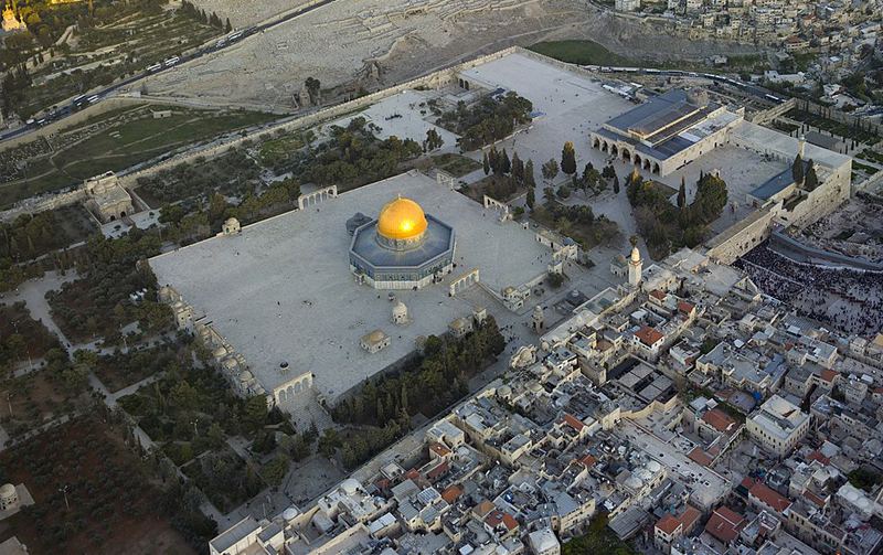
Traditional archaeology places this fortress at the northwest corner of the Temple Mount.
The alternate theory insists that the entire 35-acre platform was Antonia itself, capable of housing a full Roman legion.
But Josephus never mentioned a legion.
He wrote that a cohort was stationed there—approximately 600 soldiers, not 6,000.
This single mistranslation inflates the size of the Roman presence by tenfold.
More importantly, Roman soldiers were not the primary spatial concern in Jerusalem.
Pilgrims were.
During major festivals like Pᴀssover, ancient sources describe Jerusalem swelling with mᴀssive crowds.
Scripture itself confirms this scale.
The Temple complex needed space not only for priests and sacrifices, but for vast numbers of worshippers.
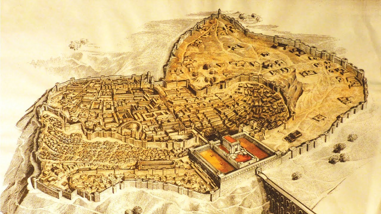
The City of David covers only about 14 acres in total.
The Temple Mount spans more than twice that area.

The Temple, with its outer courts, simply would not fit in the valley.
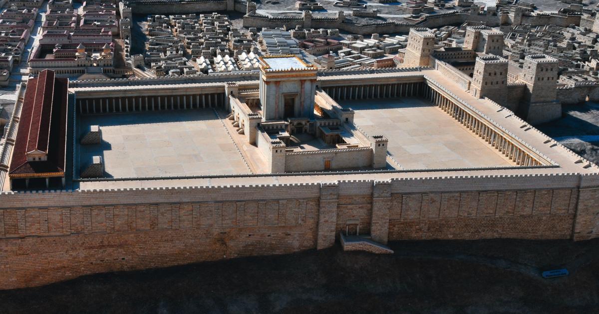
Josephus also provided a precise physical description of the Antonia Fortress.
He wrote that it was built upon a mᴀssive rock and stood where two temple courts met.
At the northwest corner of the Temple Mount, a huge bedrock outcrop still exists—perfectly matching this description.
No such geological feature exists in the City of David.
The landscape itself supports the traditional location.
Another argument claims that since the Romans destroyed Antonia, the structures visible today cannot belong to the Temple.
But ancient destruction did not mean removing every stone to bedrock.

Josephus noted that once Antonia was torn down, the Temple complex became “four-square.”
Today’s Temple Mount is slightly asymmetrical—until the northwest corner is mentally removed.
The geometry only works if Antonia was attached to the Temple Mount, not separated from it.
Measurements provide even clearer evidence.
The Bible records detailed dimensions of the Temple in cubits.
A standard ancient cubit measured between 18 and 22 inches.
Using these measurements, the Temple fits naturally on the Temple Mount.
To force it into the City of David, the cubit would need to shrink to about six inches—something no known civilization ever used.
This is not interpretation.
It is mathematical impossibility.
Water supply is often cited as the strongest argument against the Temple Mount.
The City of David contains the Gihon Spring, Jerusalem’s only natural freshwater source.
The Temple Mount has no spring—so the argument goes.
Yet this claim ignores one of the greatest engineering achievements of ancient Jerusalem.

In the 19th century, British engineer Sir Charles Warren explored beneath the Temple Mount and uncovered a vast underground water system.
Mᴀssive cisterns carved into bedrock could hold over 200 million gallons of water.
Archaeologists later traced an aqueduct stretching more than 20 kilometers from springs near Bethlehem directly to the Temple Mount.
Jewish law permits ritual water that is collected, as long as it is connected to a natural source—exactly what this system provided.
Excavations around the southern and western edges of the Temple Mount revealed dozens of mikva’ot, ritual immersion baths used before entering the Temple.
A wide pilgrim road lined with these baths climbs toward the mount.

The southern steps still visible today were designed with alternating long and short steps, forcing pilgrims to slow down in reverence as they ascended.
The City of David simply does not contain this infrastructure at the necessary scale.
Perhaps the most compelling evidence comes from artifacts.
After unauthorized construction in 1999 dumped thousands of tons of soil from the Temple Mount, archaeologists launched the Temple Mount Sifting Project.
Over 750,000 artifacts were recovered—Second Temple coins, decorative tiles, seals bearing priestly family names mentioned in the Bible, and animal bones burned exactly according to sacrificial law.

One stone stands above the rest.
Discovered at the southwest corner of the Temple Mount, it bears a Hebrew inscription referring to the “place of trumpeting,” where priests announced the Sabbath.
It fell from above during the Roman destruction in 70 AD.
It could not have traveled from the City of David.
Its resting place reveals its origin.
When all evidence is weighed—textual, archaeological, geographical, and mathematical—the conclusion is unavoidable.
The Temple stood on the Temple Mount.
It always has.


