At 12:57 a.m. local time on February 23, 2026, the earth beneath northern Borneo moved with a force Malaysia has not experienced in over a century.
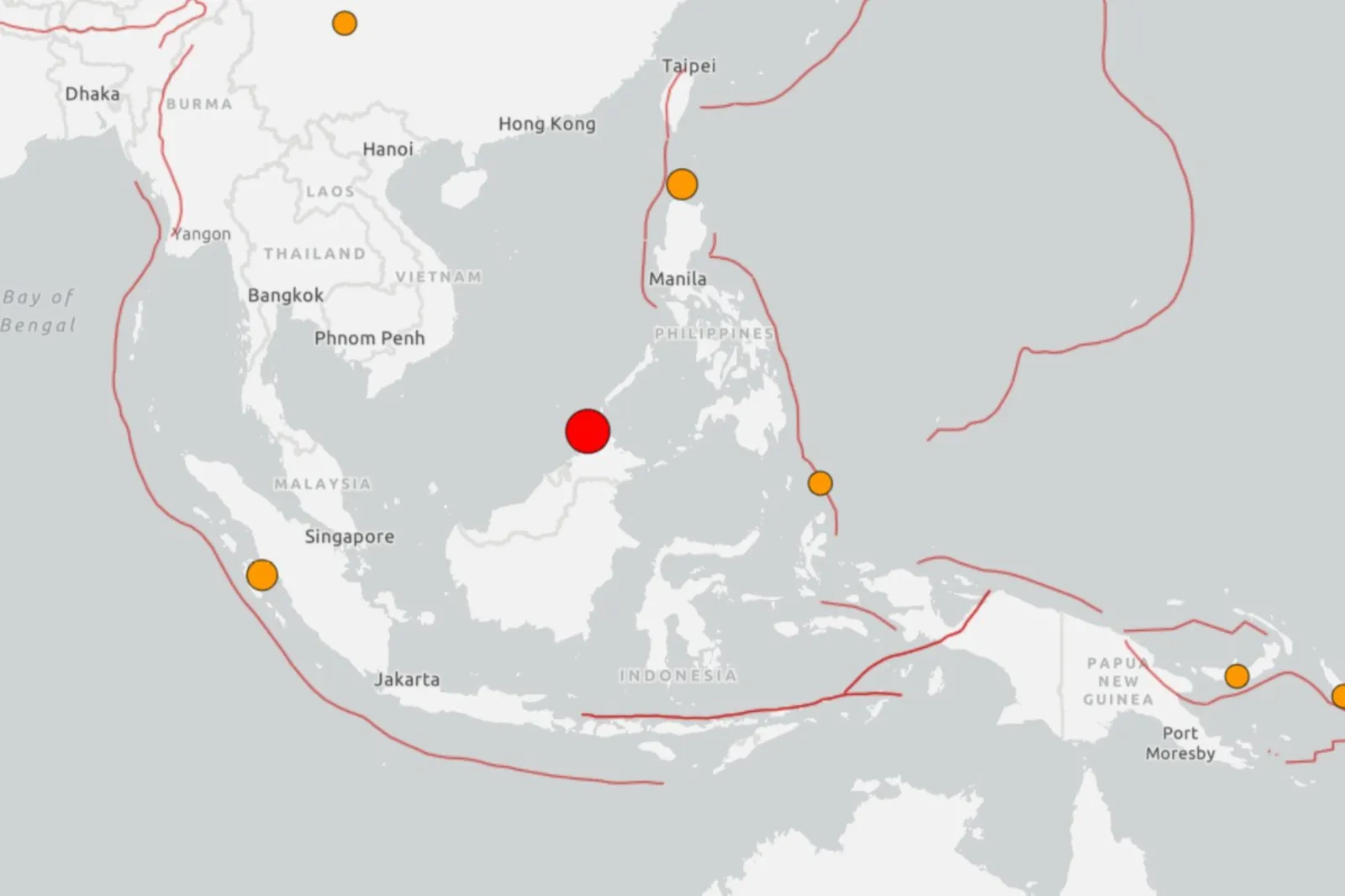
A magnitude 7.1 earthquake ruptured 620 kilometers beneath the Sulu Sea, about 55 kilometers northwest of Kota Marudu in Sabah. It was the strongest seismic event ever instrumentally recorded this close to Borneo and the largest to affect Malaysian territory since 1923 — a span of 103 years.
Nearly six million people felt moderate shaking. An estimated 78 million more felt the tremor ripple outward across Sarawak, Brunei, the southern Philippines, and into high-rise apartments in Singapore.
And yet, by sunrise, the story seemed to be over.
No casualties.
No structural damage.
No tsunami.
Deputy Prime Minister Ahmad Zahid Hamidi, chairman of the National Disaster Management Committee, activated emergency monitoring across Sabah’s coastal districts. Fire and Rescue teams deployed from Putatan to Kudat. Malaysian Meteorological Department (MetMalaysia) issued continuous bulletins through the night. The U.S. Tsunami Warning Center confirmed no ocean threat within minutes.
Officially, it was a successful non-disaster.
But the real story lies in what did not happen — and what might.
A Memorial That Shook in the Dark
Ninety-seven kilometers south of the epicenter, at the base of Mount Kinabalu in Kundasang, stands a stone memorial at Kiau Gap View.
It was erected in 2016 by the Sabah state government. Granite base. Bronze plaque. Eighteen names carved into its face — students, teachers, mountain guides.
They were killed on June 5, 2015, when a shallow magnitude 6.0 earthquake struck just 18 kilometers beneath the mountain. Rock faces tore away from Southeast Asia’s highest peak. Boulders crashed down without warning.
The ᴅᴇᴀᴅ included local guides who shielded climbers with their bodies, seven 12-year-old students from Singapore’s Tanjong Katong Primary School, and Japanese climber Masahiro Okazaki, who died protecting a child.
Every year, families return. They lay flowers. They touch the engraved names.
At 12:57 a.m. on February 23, 2026, that granite plaque vibrated in the dark.
No one stood there to feel it. But the earth beneath Sabah was doing something it has done fewer than five times in recorded history: reminding a country what a major earthquake feels like.
Why a 7.1 Did Not Destroy Anything
The difference between 2015 and 2026 was not magnitude alone.
The 2015 2015 Sabah earthquake measured 6.0 — but it was shallow, only 18 kilometers deep. Shallow earthquakes concentrate energy near the surface. They break rock. They topple structures.
The February 2026 event was far larger — 7.1 — releasing more than ten times the energy. But it ruptured 620 kilometers down, deep within the subducting Philippine Sea plate beneath the Sunda plate.
Deep-focus earthquakes behave differently. Their energy radiates outward through solid mantle rock in all directions, dispersing across enormous distances before reaching the surface. That is why roughly 84 million people felt it.
It is also why nobody died.
Depth absorbed the violence.
Had that same 7.1 occurred at 18 kilometers instead of 620, Sabah’s headlines would look very different.

The Faults Beneath Western Sabah
To understand why this matters, you have to look beneath the surface.
Northern Borneo sits at a tectonic collision zone where three major plates converge: the Eurasian plate, the Indo-Australian plate, and the Philippine Sea plate. The Manila Trench and Sulu Trench remain active subduction systems. Beneath western Sabah runs the 200-kilometer Crocker Fault System, along with the Mensaban Fault and fracture zones beneath major population centers.
These are not theoretical risks.
On February 10, 2025, a magnitude 3.8 earthquake struck Kota Marudu. Malaysia’s National Disaster Management Agency issued preparedness advisories naming active fault lines under western Sabah.
On March 28, 2025, a devastating magnitude 7.7 earthquake struck Myanmar and shook Bangkok. Malaysian structural engineers responded with urgent warnings: Kota Kinabalu, Sandakan, and Tawau had been built under outdated codes with no seismic provisions.
In April 2025, Professor Alan Adnan of Universiti Teknologi Malaysia publicly urged the country to adopt stronger seismic standards. Bridges. Elevated rail. Glᴀss façades. High-rises. None were designed for significant lateral ground motion.
A Country Without an Earthquake Code — Until 2017
Malaysia did not implement a seismic building code until 2017, when the Malaysian National Annex to Eurocode 8 was published — two years after 18 people died on Mount Kinabalu.
Every building constructed in Sabah before that date was designed with zero earthquake resistance.
Schools.
Hospitals.
Apartment towers.
Waterfront H๏τels in Kota Kinabalu.
No reinforced structural framing to absorb lateral forces. Shallow foundations on sediment. Unreinforced brick walls with concrete slabs. Pre-cast concrete frames with masonry infill — construction types widely recognized as vulnerable during seismic shaking.
In 2023, researchers from Universiti Malaysia Sabah visually inspected 555 buildings across seven districts. More than 160 buildings in Kota Kinabalu and Kudat alone were ᴀssessed as vulnerable to Grade 4 damage — partial structural collapse — in a moderate earthquake.
Retrofitting costs were estimated at 5–10 percent of structural value per building.
The question was not whether Sabah would feel another earthquake.
It was when.
The Heroism of 2015 — and the Warning Unfinished
The morning of June 5, 2015, began like hundreds before it.
Mountain guide Robbie Sapingi was leading climbers near the summit of Mount Kinabalu. When the quake struck at 7:15 a.m. and rocks began to fall, he stepped between the boulders and the climbers behind him.
He died standing in their path.
Joseph Salongjin, another guide, had spoken with his sister the night before. She was working as a nurse. When the quake hit, she dialed his phone repeatedly. There was no answer. She was on duty when his body arrived at Queen Elizabeth Hospital in Kota Kinabalu.
Ten years later, families gathered again at Kiau Gap View. Two survivors from the Singaporean student group returned to summit the peak that nearly killed them as children. Former Prime Minister Lee Hsien Loong called their climb courageous.
At the memorial ceremony, flowers were laid beneath the plaque.
The promise repeated: “Never again.”
The Safe Version of Disaster
The February 23, 2026 earthquake was classified with a green alert by international monitoring agencies — low likelihood of casualties, low economic impact. Sabah’s Fire and Rescue Department reported zero emergency calls. MetMalaysia continued routine monitoring.
Case closed.
Except nothing about this is routine.
The Crocker Fault System remains loaded with tectonic stress. The Manila and Sulu trenches continue subducting. Three converging plates still press against a state where dozens of vulnerable buildings stand over active fault zones.
The seismic code meant to fix this problem is only nine years old.
Most structures in Sabah were built decades before anyone believed Malaysia needed one.
So how do you tell 500,000 residents of Kota Kinabalu that the earthquake that shook their city at 12:57 a.m. was the safe version?
How do you explain to families who stood before 18 engraved names last June that the schools and hospitals their children use were not designed to survive the kind of shaking that killed their loved ones?
If a 7.1 — the largest seismic event near Malaysian territory in 103 years — struck Borneo and did not crack a single wall because it ruptured 620 kilometers deep, what happens when the next one ruptures at 18?
The Mountain Still Stands
At the base of Mount Kinabalu, the memorial still holds its eighteen names. The granite held. The plaque held. The mountain above it still stands.
On February 23, 2026, the ground beneath it rolled and settled again.
This time, depth was mercy.
Next time, it might not be.


