😱 California’s Central Valley in Crisis: How Groundwater Depletion is Causing Land to Sink and Property Values to Plummet! 😱
California’s Central Valley looks fertile and calm, but the ground beneath it is failing.
As the land sinks faster each year, scientists warn that the nation’s food heartland is entering a dangerous new phase.
Is sinking land tanking housing values?
A new study from UC Riverside shows excessive groundwater pumping is causing the Central Valley to gradually collapse.
Now, it may be affecting the housing market as well.
Viewed from above, the valley still shimmers with promise—patchworks of green fields, sprawling orchards, and rivers snaking through golden farmland.
But beneath this vibrant expanse, a stark reality lurks.
Underfoot, the land is collapsing, and the pace of that collapse is only accelerating.
Recent satellite data and field measurements have confirmed what many feared: vast areas of California’s Central Valley are sinking more rapidly over larger expanses and with heavier consequences than previously predicted.
The ground itself, once a symbol of abundance, is literally giving way, and the repercussions are deeper than many could imagine.
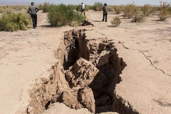
Homes and barns lean on unstable ground.
Roads ripple and buckle in the night.

In towns once symbolic of growth and prosperity, families see the ground subside—sometimes by centimeters in a year, sometimes more suddenly.
Farmers whose labor and wisdom have shaped the valley for generations now confront a new fear.
Their fields, the lifeblood of their work, are vanishing from beneath them.
As the sinking deepens, property values fall.
Infrastructure begins to fail, and the foundation of California’s food supply is put under relentless strain.
The urgency here is real and growing.
What’s happening is not just an environmental challenge; it’s an economic, social, and existential threat racing ahead of official efforts to understand or repair the damage and outpacing many residents’ ability to adapt.
Driven by constant groundwater pumping, this hidden hazard has escalated into a widespread emergency, its effects reaching into every home and farm.
But the story doesn’t end with what we see on the surface.
The visible consequences—tilting silos, splintered roads, rows of trees leaning out of line—are only the most apparent signs of a crisis rooted in the valley’s aquifers.
Every lost foot of elevation signals water that may never return.
Below the ground, aquifers, some of which took millennia to fill, are shrinking, creating risks far deeper than can be seen above.
The central question is no longer if the Central Valley will continue to sink but how much can be lost before recovery is out of reach.
What is driving this disaster, and has the moment for meaningful intervention already pᴀssed?
The scientific answer is sobering and urgent.
Dawn rises over the Central Valley, but beneath the mist and morning calm, an unseen collapse is underway.
The valley floor is changing—not in inches, but in ways that leave lasting impacts on livelihoods and communities.
Stanford researchers, using satellite data and field measurements, have tracked a swift acceleration.
The San Joaquin Valley, among the most productive agricultural regions on Earth, is now subsiding at rates that overturn previous records and models.
The collapse stretches from the edges of Bakersfield up to areas near Stockton and reaches east from the Coast Ranges across the valley.
The sinking is relentless and, in many places, irreversible.
What drives this decline?
Aquifers that once provided a seemingly limitless water reserve are now depleted.
For decades, the valley’s prosperity hinged on groundwater stored deep below.
As surface water availability faltered and irrigation needs rose, groundwater wells became lifelines.
So much so that after generations of heavy pumping, the land itself has grown weak.
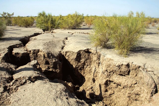
As the water table drops, soil particles compact, and the ground cannot rebound, leading to subsidence that in some places is measured in feet, not inches.
The aftermath is severe and pervasive.
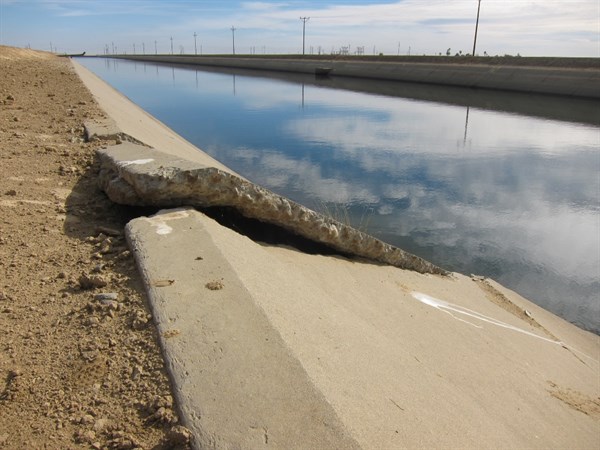
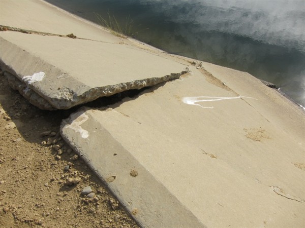
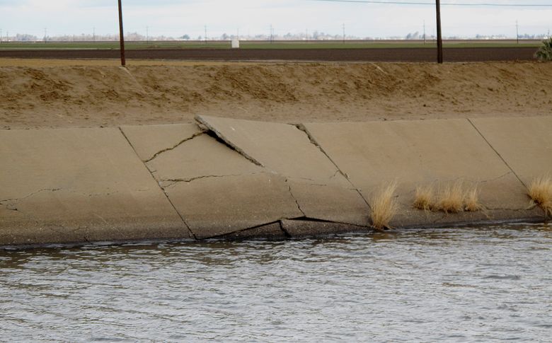
Irrigation canals built with precision now meander unpredictably, flowing uphill or cracking under new strains.
Roads and bridges built with the expectation of steady ground are now misaligned, sometimes requiring complete reconstruction.
Farmers, once focused on crop yields, are now also forced to calculate costly infrastructure repairs, and some have already left fields rendered unusable by persistent flooding or unstable soils.
The United States Geological Survey and California Department of Water Resources, monitoring live data and aerial footage, recognize that today’s subsidence often surpᴀsses even their most pessimistic projections from past decades.
Certain spots, including some near Corcoran, have witnessed ground loss approaching a foot per year—a pace that threatens not only agriculture but also every element of regional life.
As collapsing aquifers accelerate the process, experts warn that we are approaching, or have reached, limits beyond which full recovery is impossible.
For more in-depth analysis of crises across California, subscribe to our channel and stay informed on the stories that matter most.
The Central Valley’s challenge is not always dramatic in the usual sense.
Instead, it is a slow-moving catastrophe, a phenomenon that reshapes daily existence.
For generations, old families and new arrivals alike, the land’s slow descent brings both immediate and long-haul consequences.
Subtle shifts—doors that no longer close, windows that won’t align—signal the beginnings of broader disruption.
Work by UC Riverside researchers has shed new light on another dimension of the crisis.
Sinking land means declining property values.
In a place where land and home are central to personal and economic security, every new survey confirming accelerated subsidence brings further concern for both local fortunes and long-term prospects.
The economic fallout is only half the story.
Critical infrastructure is also unraveling.
Canals, pipes, and service lines buckle under shifting ground, and miles of investment are affected by misalignments or sinking.
Roads, once direct and reliable, now show cracks, dips, and detours, and bridges require constant attention or even rebuilding.
Some families drive farther than ever just to reach once-close fields as routes are rerouted around impᴀssable terrain.
Hydrology experts point out the compounding nature of the crisis.
Lost property value reduces investment, which in turn means less maintenance, further lowering values and accelerating infrastructure failures—a self-reinforcing spiral that is difficult to arrest.
With groundwater reserves drained at unsustainable rates, even the basic business of farming—the valley’s economic backbone—faces profound uncertainty.
Irrigation networks constructed for steady terrain may no longer function as intended, leading some fields to wither while others flood due to subtle changes in landscape elevation.
The problem is increasingly hard to ignore.
Satellite footage and field sensor data reveal towns, neighborhoods, and stretches of farmland altered season by season.
Geographic features documented for decades are changed, redefined, or erased by the slow loss of elevation.
Is full remediation possible given that aquifers compacted through years of pressure may never open again?
Or is the descent in some areas a permanent feature—one around which new ways of living must be imagined?
The crisis in California’s Central Valley has a clear driver: groundwater depletion.
For decades, deep well pumping offered a buffer against drought, but the true costs are now visible.
Recent diagrams from the California Department of Water Resources clearly show how groundwater removal leads to vertical loss in aquifer layers—spaces that once compressed cannot be fully restored.
This is not simply about short-term droughts, but an entrenched pattern of persistent overuse.
As water is steadily withdrawn with insufficient time or supply for natural recharge, the process accelerates.
Compaction increases, the rate of subsidence rises, and the ability of aquifers to recover diminishes further.
Soil grains, including clays and silts, settle into тιԍнтer configurations, permanently sealing once-porous spaces.

Millions of dollars in infrastructure are now at risk or already damaged.
A wave of issues extends from water distribution to roads, utilities, and homes.
Communities like Lathrop and Corcoran have felt sharp impacts with notable land loss and emergency measures taken to address infrastructure and community stability.
Visible damage is only part of the story.
Hidden below ground, electrical lines, pipelines, and fiber optics built for previous ground levels are increasingly threatened.
The risks from these hidden networks faltering compound the region’s woes.
What does it mean for a community or an entire valley when the ground can no longer be trusted?
The search is on for solutions, whether technical or regulatory, but the damage is growing quickly and will outlast any short-term fix.
Warnings about subsidence once seemed abstract, scientific, but now in the heart of the Central Valley, these changes touch daily life.
The aftermath nobody expected has become routine, reshaping everyday life, personal wealth, and regional idenтιтy.
Satellite imagery brings the scale into focus.
Over the last century, some areas have lost more than 20 ft of elevation, much of that in recent decades.
The fastest sinking agricultural land in the country now lies beneath previously record-setting fields.
Machinery, irrigation lines, and entire orchards are afflicted.
Every year of land loss pushes groundwater further out of reach, further reducing the potential for natural recovery.
For civic officials, damage reports accumulate.
Repairs to canals and roads seem endless.
What once were considered drastic solutions, such as pumping restrictions or extensive new monitoring, now appear almost modest compared to the scale of the crisis.
The problem of subsidence is now measured not just in lost elevation but in lost productivity, increased costs, and disrupted lives.
Experts at the California Department of Water Resources confirm that rates of subsidence in key areas have far surpᴀssed past expectations.
The region is in uncharted territory.
Infrastructure designed for the past can barely keep pace with the accelerating land loss.
The impacts are substantial and, in some ways, incalculable—billions of dollars lost and further challenges in quantifying the effects on local idenтιтy and stability.
The steady shifting of boundaries, loss of community features, and conversion of previously stable land into wetlands or unusable ground have become regular features in the lives of valley families.
As the land continues to fall, the sense of possibility for the future is challenged.
Can the Central Valley sustain its role as an agricultural and economic powerhouse?
Or does the era of reliable ground belong to the past?
Don’t forget to subscribe for the latest updates on California’s changing environment, and share your stories and perspectives with us below.
The story is not only told in aerial pH๏τographs and maps but also in the personal journeys of those who live here.
For individual farmers and families, the consequences are immediate.
A commute grows longer as roads are rerouted.
A family invests in a home only to watch the ground outside drop by inches over a few years, and property values become unpredictable for the first time in memory.
Real estate markets reflect shifting risks.
In cities like Fresno and Visalia, neighborhood values fluctuate as new subsidence data emerges.
Properties that once fetched a premium for prime land may linger unsold as buyers reconsider risks previously unrecognized.
Local governments try to keep up with growing costs.
Budgets for growth are redirected toward urgent repairs, emergency measures, and mitigation.
Public meetings are defined by difficult trade-offs—whether to fix canals or to reinforce public buildings, knowing that some infrastructure may not survive the next round of sinking.
Alongside these practical challenges, scientists continue to warn of risks that extend to water systems and flood patterns.
As land drops unevenly, historic water flows change, leading to new problems.
Some areas become more vulnerable to floods while others lose access to reliable surface water altogether.
These compounding risks alter more than just the landscape.
They are reshaping the sense of place and continuity that defined the valley for generations.
A growing consensus among experts is that much of the subsidence observed in California’s Central Valley cannot be reversed.
Once aquifer layers collapse, their storage capacity is permanently lost.
The spaces that took thousands of years to form are sealed by the very pressure that once sustained the land’s fertility.
The engineering and financial challenges are severe.

Repairing canals often means more than patching; it can require complete overhaul or relocation.
Road and utility repairs must now account for ground in motion, meaning solutions are only temporary for some areas.
In a few communities, the only viable option has become relocation—a hard reality for affected families and towns.
Adaptation will demand more than technology; it calls for a new mindset, shifting aspiration from recovery to resilience.
New crops may have to use less water.
Homes and infrastructure may need to be built with flexibility.
Entire communities may be planned or updated with the ᴀssumption of ongoing change, not permanent stability.
The evidence is visible across the region: sunken neighborhoods, irregular waterways, abandoned fields.
The Central Valley’s future will not mirror its past, and families and businesses are already adapting to realities none would have imagined only decades ago.
Year after year, the tally of lost ground grows.
The extraordinary has become familiar, and caution is now the order of the day.
Experts at insтιтutions like Stanford and UC Riverside note that in the past, some margin for error existed in land and water management.
Today, those margins are gone.
Every decision about groundwater use and development carries heavier consequences than ever before.
What does this mean for the region’s role as a breadbasket, feeding millions far beyond California’s borders?
What will become of towns and ways of life that rest now precariously on land in perpetual motion?
Difficult questions outpace ready answers.
Political and policy debates about water use, infrastructure investment, and land management grow in intensity but have not yet produced solutions on the scale required.
Mᴀssive projects such as new reservoirs or recharge programs are discussed, but always with the recognition that some of what is lost cannot be rebuilt.
The future of the Central Valley will depend on finding a balance with the new limits of land and water.
Residents and leaders are asked to make decisions their predecessors never faced.
When every harvest costs another few inches of ground, how does a community remain hopeful?
What is security when the ground cannot be trusted to remain?
As the footage and data pour in, the conclusion becomes inescapable: every boundary is affected.
Every community is involved.
The Central Valley’s crisis stands as a warning—a testament to the consequences of overuse and the challenges of living within ecological boundaries.
Night falls over the valley.
The land settles imperceptibly, but the legacy of both the bounty and the loss will echo across generations.
The valley’s people remain resilient and determined, searching for footing as the terrain shifts through every community and every family.


