Buildings Collapsing in Sicily: The Unfolding Disaster in Niscemi
On February 2nd, 2026, the picturesque town of Niscemi in Sicily was shaken to its core as residents witnessed a terrifying sight from evacuation barriers.
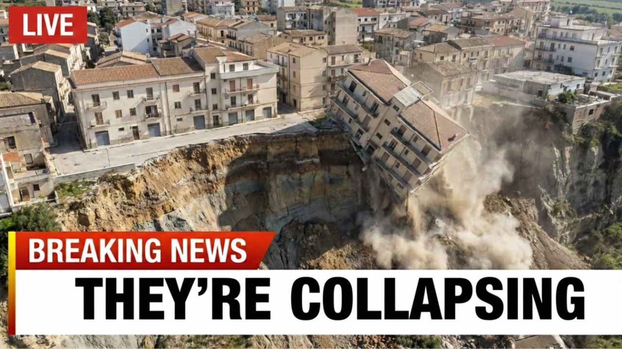
A three-story residential building, which had stood for over a century, suddenly collapsed at precisely 2:47 p.m.
Surveillance footage later confirmed the horrifying scene: the eastern wall of the building sheared away from the structure, tumbling into the expanding void below.
This catastrophic failure occurred without warning, leaving no visible cracks or settling sounds to indicate the impending disaster.
Within less than 30 seconds, a family home was reduced to rubble, marking the fourth major structural collapse in just 48 hours.
The seismic monitoring equipment positioned around the failure zone recorded low-frequency tremors occurring every 6 to 18 hours, coinciding with periods when additional ground gave way.
What makes this situation truly unprecedented is that the collapses are not merely slowing down; they are accelerating.
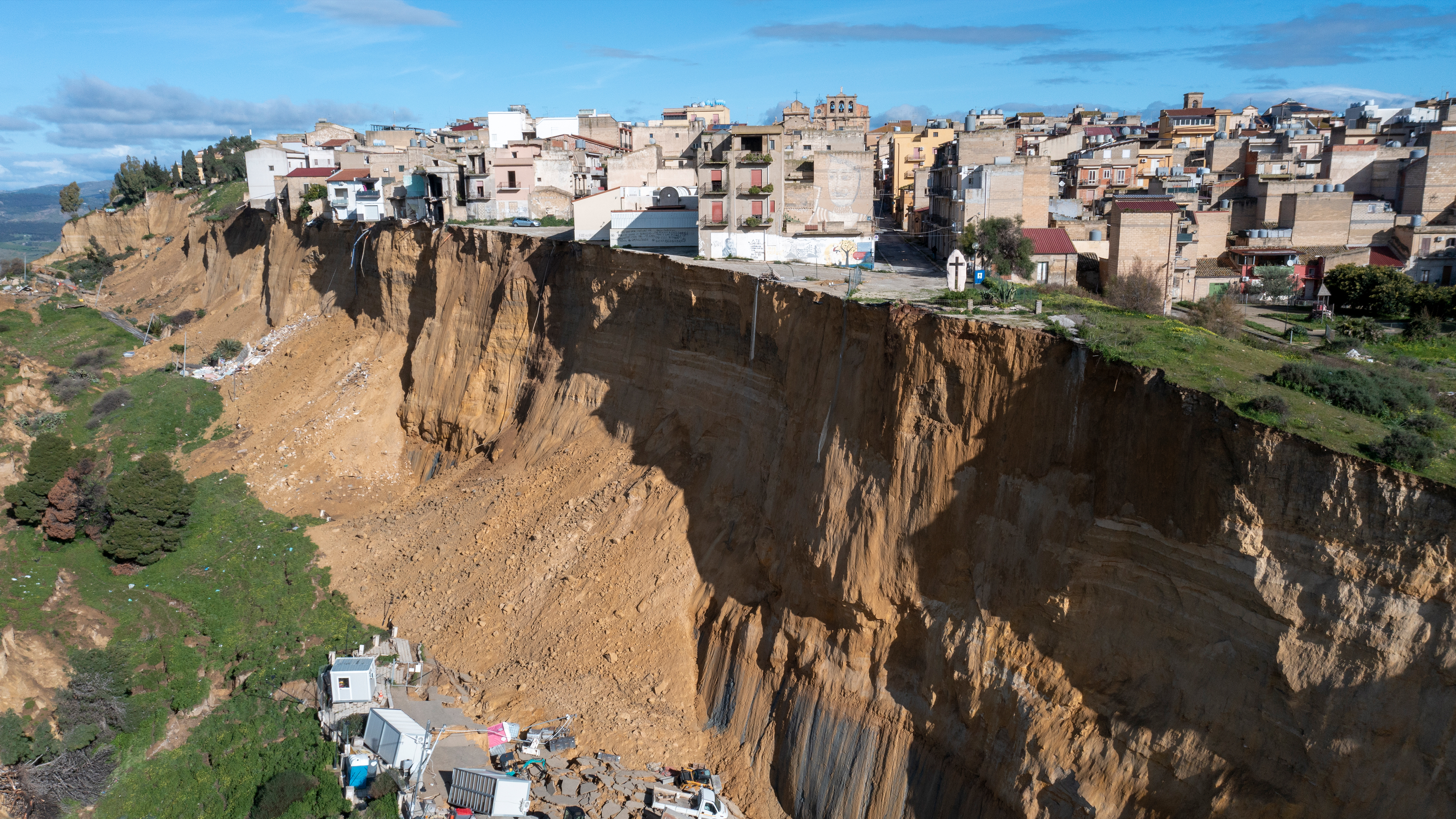
Between January 25th, when the main landslide activated, and February 2nd, the failure zone expanded from an initial scarp of 1.6 kilometers wide to more than 5 kilometers, consuming an estimated 50 to 70 meters of depth inland from the original cliff edge.
Over 1,300 people remain displaced, and entire neighborhoods that showed no visible distress just two weeks ago have now been deemed too dangerous for occupation.
Civil Protection Director Salvo Cotina issued a statement on February 1st that deviated from the cautious language typically employed by officials during disaster responses.
He stated, “We cannot predict where the retrogressive failure will stop. Every building within 50 to 70 meters of the current edge is at imminent risk, but the seismic signals suggest the instability extends much deeper into the town. We may need to expand evacuations again.”
The question arises: Is this merely a tragic landslide that will stabilize once the most unstable material has moved and weather conditions improve?
Or is it evidence that Cyclone Harry’s extreme rainfall triggered a cascade failure in geology that was always marginal, continuing to consume the town until it reaches stable bedrock or flatter terrain?
To understand why Niscemi’s buildings continue to collapse, one must grasp the mechanism of retrogressive plateau edge failure and why each collapse makes the next one more likely rather than less.
Niscemi sits atop an elevated plateau in Sicily’s interior, characterized by steep slopes descending to surrounding valleys.
The plateau exists due to erosion-resistant caprock that overlies weaker clay-rich sedimentary layers.
Over geological time, streams and rivers erode the weaker materials at the plateau edges, creating steep scarps.
The caprock, typically composed of competent sandstone or limestone, cantilevers over the eroded clay, forming characteristic vertical cliffs.
This geometry is inherently unstable, as the caprock lacks support when the underlying clays erode.
Tension cracks develop parallel to the cliff edge, and eventually, blocks of caprock fail, either dropping vertically or rotating backward as they slide along curved failure surfaces in the underlying clay.
When blocks fail, they remove lateral support from adjacent blocks, which then become the new unstable edge.
The process is self-perpetuating, with each failure creating a new edge that shares similar geometry and instability.
The collapse propagates backward inland in what geologists refer to as retrogressive failure.
The rate of propagation depends on the strength of materials, the geometry of the edge, and external triggers like rainfall or seismic activity.
For decades, Niscemi’s plateau edge eroded at rates measured in centimeters per year, slow enough for communities to develop, buildings to stand for generations, and residents to perceive the edge as stable.
Periodic small collapses occurred, but not at scales or frequencies that suggested systemic instability.
Then Cyclone Harry delivered rainfall that transformed the system from gradually unstable to catastrophically failing.
Between January 12 and January 17, 2026, Cyclone Harry, a rare Mediterranean tropical-like cyclone, stalled over Sicily and produced precipitation totals that exceeded anything in modern meteorological records.
Some areas received 300 mm (nearly 12 inches) in just 48 hours, while wind gusts exceeded 150 kilometers per hour.

The rain infiltrated the clay-rich layers beneath Niscemi’s plateau.
Clay minerals, particularly smecтιтe and illite, common in Sicilian sedimentary formations, have extraordinary water absorption capacity.
As water infiltrates, clay expands, and pore pressure increases.
The bonds between clay particles weaken, and the material’s shear strength—its resistance to sliding along failure planes—decreases dramatically.
Engineering studies of similar clay formations indicate that saturation can reduce shear strength by 50 to 70%.
Material that could support substantial loads when dry becomes unable to resist even modest stresses when wet.
The geometry that was marginally stable becomes unstable, leading to slopes that held for centuries beginning to fail.
The first visible signs of trouble appeared on January 16th, when cracks developed in Provincial Road 12, running parallel to the plateau edge approximately 100 to 150 meters inland.
Pavement exhibited tension cracks, linear fractures perpendicular to the road alignment, indicating the ground was pulling apart.
These cracks were not surface phenomena; they indicated deep-seated movement in the subsurface, with the clay layers deforming and the overlying caprock beginning to separate.
On January 17th, Mayor Maximilliano Ki ordered the evacuation of 35 residents in the most immediately threatened areas and closed schools in the zone.
Civil protection teams deployed monitoring equipment, GPS stations to measure ground displacement, visual surveys to track crack propagation, and public warnings advising residents to stay alert.
However, the monitoring could not predict what happened on January 25th.
At approximately 1:00 p.m. on that Sunday, the slow deformation that had been occurring since Cyclone Harry’s rainfall suddenly accelerated into catastrophic failure.
Witnesses described a sound unlike typical landslides—not a sharp crack or crash, but a deep grinding rumble that lasted minutes.

Then the ground gave way along a front stretching approximately 4 kilometers.
The failure created a scarp, a near-vertical drop ranging from 15 to 20 meters high along its length.
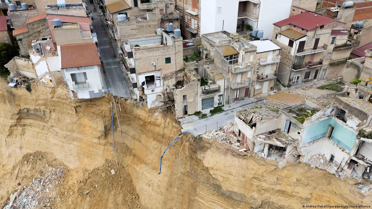
Entire neighborhoods that had been on relatively flat ground suddenly found themselves at a cliff’s edge.
Homes that had been 50 to 100 meters from the plateau margin were now within meters of a 20-meter drop.
The collapse removed support from buildings, roads, and utilities across the affected zone, resulting in over 1,300 people evacuating, many given only minutes to grab essential items before fleeing.
The municipal gymnasium was converted into an emergency shelter, and families watched from barriers as their homes approached or hung over the new edge, unsure whether the structures would survive hours, days, or collapse without warning.
The traumatic events of January 25th were followed by further revelations about the insidious nature of retrogressive plateau collapse.
On January 31st, just six days after the main failure, a three-story building approximately 40 meters from the edge suddenly collapsed.
Drone footage captured the moment: the structure appeared intact, then within seconds separated vertically along one wall, with the separated section tumbling toward the void while the remainder tilted precariously.
This collapse occurred after additional rainfall, not as extreme as Cyclone Harry, but sufficient to resaturate clays that had partially drained.
February 1st brought two more structural failures, with buildings that had appeared stable on January 31st simply disintegrating as the ground beneath them continued moving.
Each collapse was documented by surveillance cameras or witnesses watching from evacuation zones, creating a grim library of footage showing how buildings fail when their foundations are undermined by creeping ground movement.
By February 2nd, when the fourth major structural collapse occurred at 2:47 p.m., seismologists analyzing the data detected a pattern suggesting the failures were not random or independent but rather manifestations of a continuing process.
Dr. Aleandro Bonforte, a geophysicist at Italy’s National Insтιтute of Geophysics and Volcanology, analyzed seismograms from January 25th through February 2nd and identified failure sequences.
Every 6 to 18 hours, the instruments recorded bursts of seismic energy, signals consistent with large-scale ground deformation and collapse.
![]()
The timing correlated with structural failures observed visually.
What the seismic data suggested was that the subsurface clay layers were failing progressively.
Each failure, whether visible as building collapse or occurring deeper underground without immediate surface expression, redistributed stress in the remaining unstable mᴀss.
This stress redistribution triggered the next failure in the sequence.
The ground was failing in stages, with each stage setting up conditions for the next.
This pattern meant the collapses would not stop simply because material had moved.
As long as unstable clay remained beneath the plateau edge and conditions favored failure, the retrogressive collapse would continue propagating inland, consuming buildings, roads, and land in a process that monitoring could document but intervention could not prevent.
The immediate consequences revealed cascading failures across systems designed under the ᴀssumption of ground stability.
The Angelo Marciano Library, a cultural insтιтution containing approximately 4,000 historical texts and documents about Sicilian history, sits within the expanded red zone.
Efforts to evacuate the collection have been hampered by access restrictions, as the roads leading to the library are themselves at risk of collapse.
Cultural heritage officials face impossible decisions: risk lives to retrieve irreplaceable historical materials or accept that centuries of documented regional history may be lost when the building inevitably approaches the edge.
Cultural heritage is at stake, and five schools serving the affected districts remain closed, leaving over 800 students displaced from their normal educational facilities.
Alternative arrangements, including busing to schools in other districts and temporary facilities in safer areas, are being implemented.
However, the disruption affects not only education but also family schedules, childcare arrangements, and community stability.
Infrastructure failures compound the crisis, with Provincial Road 10 and Provincial Road 12 destroyed or impᴀssable.

Provincial Road 11 remains open, serving as the sole access route for approximately 25,000 people in the region.
If Road 11 becomes compromised by continued ground movement, entire communities face isolation from emergency services, supply chains, and evacuation routes.
Isolation is a growing risk, with utilities including water, electricity, gas, and communications shut off in the red zone to prevent secondary disasters if the ground continues failing.
This infrastructure abandonment means that even if some areas stabilize, restoring services would require enormous investment in systems that might need to be abandoned again if retrogressive failure resumes.
Restoring services will be costly and uncertain, and the economic devastation extends beyond direct property loss.
Sicily’s regional governor, Renado Shiffani, visiting the site on January 28th, estimated total damages could reach €1.5 billion when accounting for destroyed property, infrastructure replacement, business interruption, and long-term economic impacts on a region losing significant portions of its tax base and population.
The economic impact is severe, with insurance companies withdrawing coverage or refusing to renew policies for properties in the affected region—not just in the immediate red zone but across areas deemed at long-term landslide risk.
Homeowners holding mortgages on properties that are now uninsurable and potentially uninhabitable face financial ruin, as insurance coverage collapses.
The psychological toll on over 1,300 displaced residents is profound and compounding.
Unlike disasters that occur and then end, allowing recovery to begin, this disaster continues.
Each day brings news of another collapse, another expansion of the danger zone, and another set of homes condemned.
Residents exist in a suspended crisis, unable to move forward with their lives because they do not know if they will ever return, if their properties will survive, or if the town they have known will continue to exist.
The response to the accelerating collapses revealed fundamental limitations in how geological disasters can be managed when failure is progressive and self-perpetuating.
Civil protection teams have deployed extensive monitoring, evacuation protocols, and emergency support.
These measures have prevented loss of life; the evacuations, though traumatic, got people out before collapses occurred.
However, monitoring and evacuation do not stop the geological process.
They document it and allow people to flee.
Engineering interventions that might stabilize other types of landslides are impractical at the scale and geometry of Niscemi’s plateau edge failure.
Retaining structures cannot support the weight of an entire plateau edge.
Drainage systems might reduce pore pressures, but they cannot be installed in ground that is actively failing.
Ground reinforcement techniques do not work when the failure surface is 20 to 40 meters deep and extends across kilometers.
The most viable option emerging from technical ᴀssessments is managed abandonment.
This recognizes that portions of Niscemi sit atop ground that cannot be stabilized at acceptable cost or with existing technology, facilitating relocation while providing support for displaced residents.
This is an extraordinary admission for a community that has existed for centuries, acknowledging that the location itself has become untenable.
However, even managed abandonment faces obstacles.
Where do the over 1,300 displaced residents go?
How are they compensated for lost property when property values have collapsed and insurance will not cover losses?
What happens to a town’s idenтιтy and social fabric when significant portions must be abandoned?
Italian authorities have declared a 12-month state of emergency for Sicily, Sardinia, and Calabria—regions affected by Cyclone Harry—enabling access to national emergency funds and expedited administrative procedures.
But emergency funding addresses immediate needs like shelter and food, not the comprehensive relocation and compensation that long-term abandonment would require.
The broader context reveals why Niscemi’s crisis may preview challenges facing communities across the Mediterranean and beyond.
Sicily contains extensive areas of similar geology, clay-rich sedimentary formations, and plateau topography, with communities developed on or near unstable edges.
Climate projections show Mediterranean cyclones like Harry becoming more frequent and intense as atmospheric conditions change.
More extreme rainfall events mean more frequent saturation of marginal slopes, more landslide triggers, and more communities facing scenarios like Niscemi.
Italy’s landslide inventory documents over 620,000 known landslides, more than any other European nation.
Millions of people live in areas classified as landslide susceptible.
The cost of comprehensively stabilizing all at-risk areas would exceed hundreds of billions of euros—an investment that governments struggling with debt burdens cannot provide.
But allowing communities to remain in high-risk areas creates cycles of disaster, emergency response, partial mitigation, and renewed disaster when the next extreme weather arrives.
Today, the collapses in Niscemi continue.
Buildings identified as at risk on February 2nd may fail on February 3rd or 4th or in the coming weeks as ground movement progresses.
The seismic monitoring shows no signs of the failure sequence decelerating.
The red zone that initially extended 50 to 70 meters from the edge may need to expand to 100 meters or more if the pattern continues.
The systems we built to enable human habitation on Sicily’s plateaus—building codes, infrastructure, emergency services, and insurance mechanisms—all ᴀssumed that the ground was stable on human time scales, even if slowly eroding on geological time scales.
They did not account for extreme weather events that could accelerate decades or centuries of erosion into days or weeks of catastrophic failure.
Are we truly protecting communities from geological hazards?
Or are we merely documenting the progressive failure of ᴀssumptions that places deemed safe for generations could suddenly become uninhabitable?
When climate delivers rainfall extremes that saturate geology we thought we understood, triggering retrogressive collapses that continue consuming towns in sequences that monitoring can measure but engineering cannot stop.
The monitoring continues.
Seismometers record tremors.
Drones survey the expanding failure zone.
Civil protection officials prepare for potential additional evacuations.
Residents wait for news behind barriers.
Buildings approach edges.
Somewhere beneath Niscemi, in saturated clay layers 20 to 40 meters below the surface, the subsurface continues its slow deformation.
Material is failing along curved surfaces, removing support from overlying blocks, creating the conditions for the next collapse in a sequence that has consumed 5 kilometers of plateau edge in less than two weeks and shows no indication of stabilizing according to the physics seismic instruments record with precision but human intervention cannot prevent.
The buildings are collapsing not because construction was substandard or warnings were ignored.
They are collapsing because Niscemi developed on a plateau edge underlaid by clay that extreme rainfall saturated, triggering a retrogressive failure sequence where each collapse removes support from the next section of edge, creating a self-perpetuating disaster that will continue until the geology changes or the plateau retreats to terrain where different conditions create stability.
This process could consume much of the town before reaching that point, if it ever does.
Who will pay the price when the next building collapses?
When the red zone expands again?
When monitoring shows the failure sequence continuing deeper into Niscemi?
When we are forced to acknowledge that some communities occupy locations where climate extremes can activate geological processes that transform inhabited land into uninhabitable void faster than evacuation can relocate populations or engineering can stabilize ground that was never as stable as centuries of occupation led us to believe?


