The Silent Trail of MH370: A Mystery Still Unfolding Beneath the Indian Ocean
On March 8, 2014, Malaysia Airlines Flight MH370 departed Kuala Lumpur for Beijing with 239 people on board. Less than an hour later, it vanished from civilian radar. No distress call. No warning. Just silence. In an era defined by constant connectivity, a Boeing 777—one of the most advanced commercial aircraft in service—simply disappeared.
The final routine transmission from the cockpit came at 1:19 a.m.: “Good night, Malaysian Three Seven Zero.” Within 90 seconds, the aircraft’s transponder was manually switched off. To civilian air traffic controllers, the jet ceased to exist.
Yet military radar would later reveal something deeply unsettling: the plane had turned sharply westward, crossing back over Malaysia in what appeared to be a deliberate maneuver.

This was no uncontrolled drift. Radar data suggested a calculated redirection. The aircraft flew along the boundaries between flight information regions—a tactic known as “seam crawling”—which may have delayed detection. It then continued northwest over the Strait of Malacca before disappearing from military radar range at 2:22 a.m.
If radar lost the aircraft, satellites did not.
High above the Indian Ocean, an Inmarsat communications satellite continued exchanging automated signals—“handshakes”—with the aircraft for seven hours after it vanished from radar. These signals contained no location data, but they provided two crucial measurements: Burst Timing Offset (BTO), indicating distance from the satellite, and Burst Frequency Offset (BFO), reflecting motion through Doppler shifts.
From these faint electronic echoes, investigators reconstructed a haunting trajectory. MH370 had not turned north toward Asia, as some early theories proposed. Instead, it flew south—deep into the remote expanse of the southern Indian Ocean. The final handshake at 8:19 a.m. pointed to a vast arc of ocean thousands of miles from its intended destination.
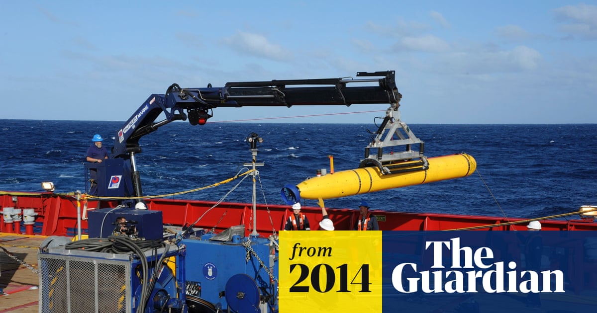
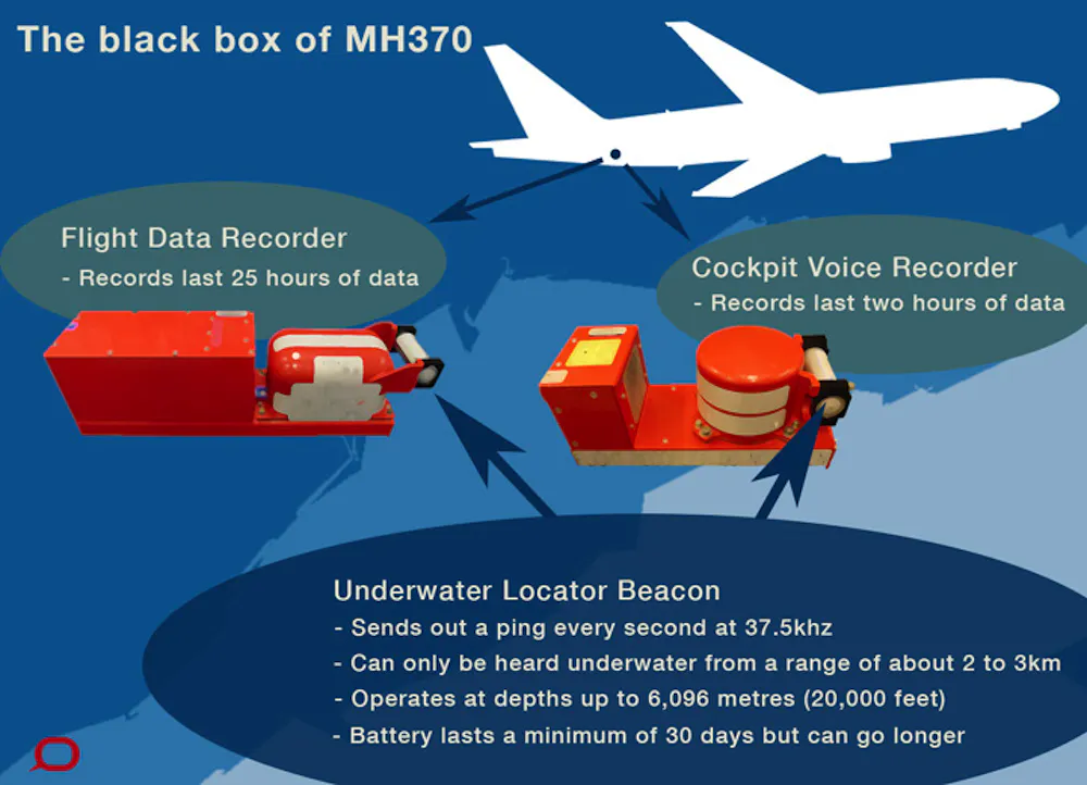
The search that followed became the most complex and expensive underwater recovery operation in aviation history. The southern Indian Ocean is no gentle seabed. It is a landscape of underwater ridges, volcanic formations, and trenches plunging thousands of meters into darkness. Initial efforts focused on detecting the aircraft’s black box pingers, which emit signals for approximately 30 days after submersion. Despite brief acoustic detections, no confirmed locator beacon was ever recovered.
Sonar mapping began on an unprecedented scale. Over 120,000 square kilometers of seabed—an area comparable to the size of Greece—were scanned. Autonomous underwater vehicles (AUVs) combed the ocean floor, capturing high-resolution images and identifying anomalies. Old shipwrecks and geological formations were discovered, but not the Boeing 777.
Then, in July 2015, the ocean delivered its first physical clue. A barnacle-encrusted flaperon—a wing control surface from a Boeing 777—washed ashore on Réunion Island. More debris followed in Mozambique, Madagascar, and South Africa.
Ocean drift modeling and marine biology analysis confirmed what satellite data had suggested: the aircraft had ended its journey in the southern Indian Ocean.

Forensic examination of the debris raised chilling possibilities. Some fragments bore signs of high-energy impact. Notably, analysis of a right outboard flap suggested it may have been retracted at impact. In a controlled water landing, flaps are typically extended to reduce speed and increase lift. A retracted configuration pointed instead toward a high-speed descent—possibly after fuel exhaustion left the aircraft on autopilot.
By 2017, the official multinational search was suspended. The mapped zones had yielded nothing definitive. But technology has advanced rapidly since then.

In 2026, a renewed private-sector effort led by Ocean Infinity deployed a new generation of deep-sea drones capable of diving to 6,000 meters. Unlike earlier tethered systems, these AUVs operate independently for up to 48 hours, scanning the seabed with extraordinary precision. Equipped with magnetometers, they can detect large metallic objects buried beneath layers of sediment—even if hidden from sonar view.
The mission strategy focuses on previously overlooked blind spots—areas obscured by underwater ridges during earlier scans. By “seam crawling” across jagged terrain and descending into deep crevices, the drones aim to eliminate every remaining uncertainty within the highest-probability search zones.

As of early 2026, thousands of additional square kilometers have been surveyed. No confirmed wreckage field has yet been announced publicly, but investigators continue narrowing the possibilities with methodical precision.
Beyond the technological pursuit lies the enduring human question: what happened inside the cockpit?
Two dominant theories persist. The “ghost flight” hypothesis suggests a catastrophic event—perhaps fire or decompression—incapacitated the crew and pᴀssengers, leaving the aircraft to fly on autopilot until fuel exhaustion.
The “rogue pilot” theory argues that the precision of the flight path and system shutdowns indicate deliberate human control. Scrutiny of the captain’s home flight simulator, which reportedly contained routes resembling the southern trajectory, has fueled debate, though no conclusive evidence has proven intent.
Without the cockpit voice recorder and flight data recorder, certainty remains elusive.
Yet MH370 has reshaped aviation safety. The tragedy accelerated implementation of the Global Aeronautical Distress and Safety System (GADSS), improved real-time aircraft tracking, and strengthened black box transmission standards. A disappearance of this magnitude is far less likely today.

Still, twelve years later, the silence endures.
Somewhere beneath miles of cold, crushing water lies the final chapter of MH370.
Whether discovered tomorrow or decades from now, the search continues not only for wreckage—but for understanding. The ocean may delay its answers, but history suggests it does not keep them forever.


