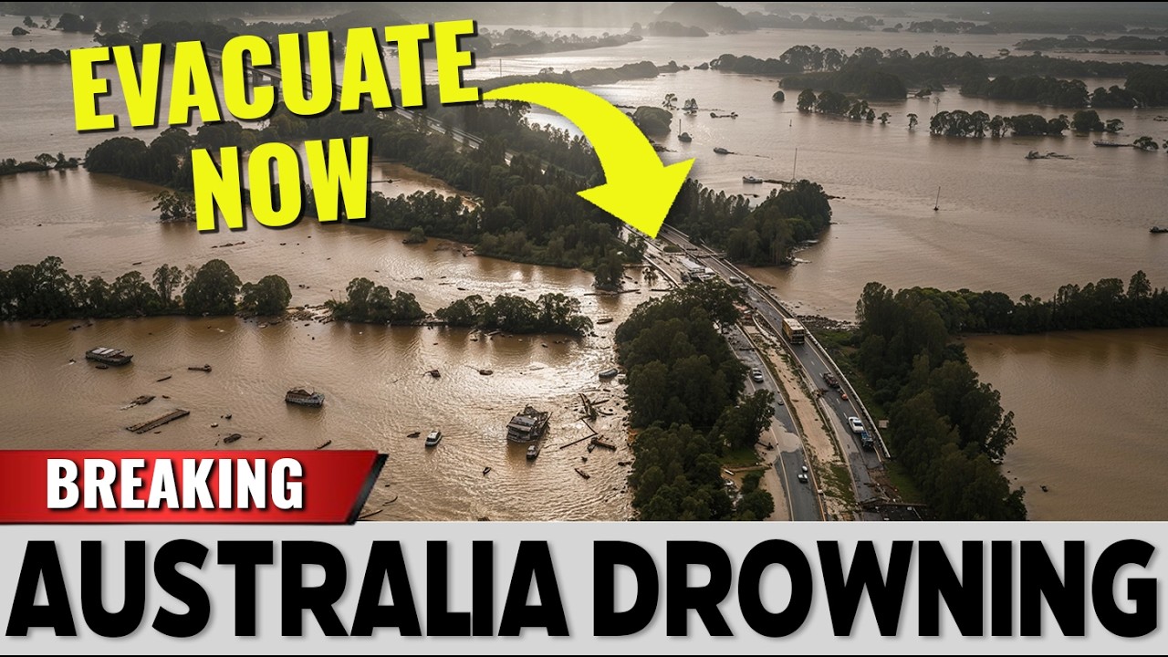
“It Won’t Let Up”: Australia’s Flood Crisis Escalates as Entire Communities Brace for the Worst
The warnings did not arrive with dramatic music or flashing sirens.
They came in measured tones from the Bureau of Meteorology, delivered in the restrained language of charts, satellite loops, and rainfall totals.
Yet beneath the clinical phrasing was a line that has since echoed across social feeds and emergency briefings alike: the rainband over Australia “won’t let up.”
It is a simple phrase.
But on the ground, it feels less like a forecast and more like a verdict.
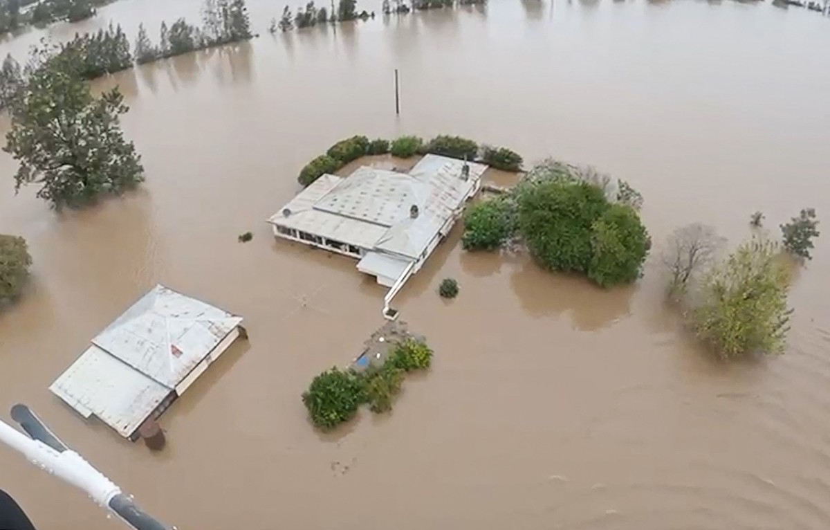
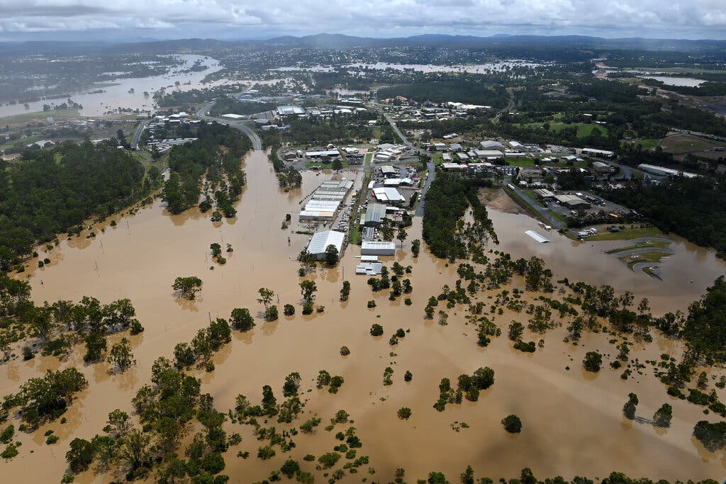
Across multiple regions, swollen rivers have slipped quietly beyond their banks, at first nudging into low-lying paddocks and empty roads, then creeping toward homes that were never meant to know the sound of lapping water at their front doors.
In some towns, residents describe waking in the dark to a low, continuous hum — rain striking metal roofs with mechanical persistence.
No thunder.
No lightning.
Just a steady descent, as if the sky has chosen endurance over spectacle.
Satellite imagery shows a dense band of cloud locked into position, repeatedly drawing moisture inland.
Meteorologists describe it as a stalled system, fed by atmospheric conditions that have aligned with unnerving precision.
Each new model run appears to extend the timeline.
Each update subtly revises the accumulation totals upward.
Officials stop short of using words like “unprecedented,” but comparisons to past disasters are circulating nonetheless.
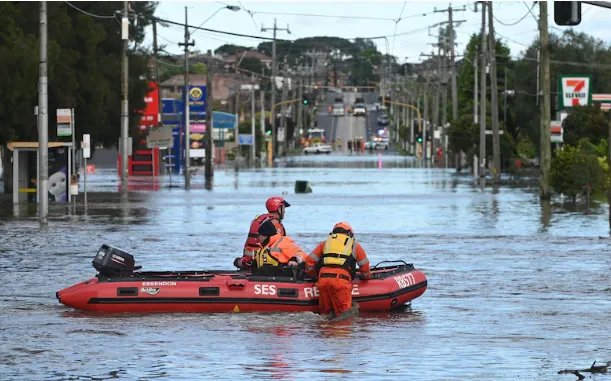
Emergency services have issued evacuation orders in select areas.
Sandbags line shopfronts that only days ago displayed ordinary signs of routine life — weekend sales, café menus, community events.
Now the streets are muted, interrupted by the occasional engine of a rescue vehicle navigating waterlogged intersections.
In certain pockets, power has flickered or failed entirely.
At night, the darkness feels heavier, broken only by the reflection of floodwater catching distant headlights.
Some residents insist they have seen this before.
Australia has always been a continent of extremes — drought and deluge, fire and flood.
Cycles repeat.
Records are broken.
Then life resumes.
But others point to the subtle differences: the duration, the saturation levels, the way the rain seems less violent yet more relentless.
This is not a storm that rages and retreats.
It lingers.
In community halls repurposed as evacuation centers, conversations oscillate between practical logistics and uneasy speculation.
Insurance forms are discussed alongside rainfall graphs.
Children scroll through videos of submerged parks that were playgrounds only a week prior.
Volunteers distribute blankets and bottled water, careful to project calm.
Yet the underlying question — how long — hangs unspoken.
The Bureau’s official bulletins remain measured.
They reference catchment capacity, riverine flooding, flash flood risks, and cumulative impacts.
They emphasize preparedness and adherence to warnings.
Still, when a senior forecaster acknowledged that the rainband showed “no clear sign of easing in the immediate term,” it was enough to ignite a wave of commentary online.
Some accuse authorities of underplaying the severity to avoid panic.
Others argue the opposite — that the language is intentionally stark to compel compliance.
There is also the matter of infrastructure.
Roads designed for seasonal storms now endure days of continuous submersion.
Bridges carry not just vehicles but the weight of saturated soil pressing against their foundations.
Engineers monitor stress points, aware that failure rarely announces itself in advance.
A culvert blocked by debris can redirect water in unexpected directions.
A levee tested beyond its design threshold can transform reᴀssurance into regret.
Farmers in affected regions speak in quieter tones.
Fields that promised harvest now resemble shallow lakes.
Livestock have been moved where possible, but access routes are narrowing.
For some, the financial implications are immediate and measurable.
For others, the damage will reveal itself weeks later, when crops fail or soil quality declines.
The rain does not discriminate between urban and rural; it accumulates with impartial persistence.
Meteorologists explain the broader atmospheric setup with technical clarity: moisture-laden air streams, upper-level troughs, pressure systems that have aligned to create a conveyor belt of precipitation.
None of this is inherently mysterious.
Weather, after all, obeys physical laws.
Yet the predictability of the mechanism does little to reduce the psychological weight of watching the radar remain unchanged day after day.
There are stories circulating — difficult to verify, easy to amplify.
Claims of certain neighborhoods receiving far more rainfall than forecast.
ᴀssertions that drainage systems were neglected despite prior warnings.
Suggestions that climate variability is accelerating faster than infrastructure can adapt.
In the absence of immediate relief, speculation fills the vacuum.
Social media feeds blur the line between confirmed updates and conjecture.
Authorities have neither confirmed nor dismissed many of these narratives outright.
Instead, they reiterate guidance: monitor official channels, avoid flooded roads, prepare for extended impacts.
The repeтιтion is deliberate.
Consistency, they hope, will counter confusion.
Yet consistency is precisely what unsettles some observers.
The rain does not spike dramatically; it persists.
Rivers do not surge in a single catastrophic wave; they rise incrementally, hour by hour.
The danger is cumulative.
By the time thresholds are breached, the process has already been underway for days.
In certain towns, residents describe a peculiar stillness between downpours — not a cessation, but a softening.
The air grows heavy, almost expectant.
Birds retreat.
The usual ambient sounds diminish.
Then the rain resumes, steady and unembellished.
It is this rhythm, rather than any singular dramatic moment, that erodes confidence.
Economic analysts are beginning to estimate potential losses.
Retail interruptions, agricultural setbacks, infrastructure repairs — the figures accumulate much like the rainfall itself.
Insurers caution that ᴀssessments will take time.
Government representatives pledge support packages, though specifics remain under discussion.
In the interim, individuals calculate their own margins of endurance.
Critics question whether long-term planning has adequately accounted for scenarios like this.
Supporters counter that no system can be entirely floodproof against prolonged, high-volume events.
The debate is not new, but the current conditions lend it renewed urgency.
When forecasts repeatedly extend, patience thins.
There is also the human factor — fatigue.
Continuous alertness drains communities.
Each weather update demands attention.
Each rumor requires evaluation.
Sleep becomes fragmented when rain drums without pause.
The psychological toll, though less visible than inundated streets, is tangible.
And still, the central statement remains unchanged: the rainband “won’t let up.” Meteorologists are careful to frame this within forecast windows and probability ranges.
Weather systems eventually shift.
Patterns evolve.
But the absence of a clear endpoint fuels unease.
It is easier to brace for a defined impact than for an open-ended one.
As waters edge closer to historical markers in certain river gauges, comparisons intensify.
Past flood years are invoked — sometimes accurately, sometimes selectively.
Records matter, but so does context.
Urban expansion, altered landscapes, and climate variability complicate direct parallels.
Each event carries its own configuration of risk.
At the periphery of official briefings, a quieter acknowledgment emerges: adaptation may require more than temporary defenses.
Conversations about zoning, drainage upgrades, and resilience frameworks gain traction.
Yet such measures unfold over years, not days.
The current crisis demands immediate response.
Late at night, when official channels fall silent between scheduled updates, the rain continues.
It does not trend.
It does not debate.
It accumulates.
By dawn, new footage surfaces: a submerged car park, a swollen creek overrunning its banks, a family loading belongings into a vehicle under gray skies.
None of these images alone defines the moment.
Together, they suggest a pattern that resists easy framing.
Whether this event will ultimately be cataloged as historic, anomalous, or indicative of a broader shift remains to be seen.
Data will be analyzed.
Reports will be compiled.
Infrastructure will be repaired.
But for now, communities measure time not in days but in millimeters.
The forecast will update again.
The phrasing may adjust slightly.
Percentages will recalibrate.
Yet until the radar shows a decisive break, the prevailing sentiment is suspended between vigilance and disbelief.
In the end, the controversy may not hinge on whether the rain fell harder than expected, but on how long it chose to stay — and whether the systems designed to withstand it were prepared for endurance rather than intensity.
For the residents watching the waterline inch higher, that distinction feels less academic than immediate.
The rain does not announce its intentions.
It simply continues.


