From Mount Mazama to Axial Seamount: Could Oregon Face Another Collapse?
In southern Oregon lies Crater Lake — a body of water so deep and intensely blue that it feels almost otherworldly. At 592 meters (1,943 feet), it is the deepest lake in the United States. But its beauty hides a violent origin.
Around 7,700 years ago, Mount Mazama stood where Crater Lake now rests. The volcano once towered approximately 3,700 meters (12,140 feet) high, rivaling Mount Fuji in size. For hundreds of thousands of years, it grew through repeated eruptions as part of the Cascade Volcanic Arc, fueled by the subduction of the Juan de Fuca Plate beneath the North American Plate.
But roughly 30,000 years before its final eruption, Mazama’s behavior changed.

Its magma became increasingly rich in silica — forming rhyolite, a thick, viscous, and highly explosive material. High-silica magma traps gases efficiently, allowing immense pressure to build underground. Over time, an enormous magma reservoir accumulated beneath the volcano — estimated at roughly 50 cubic kilometers (12 cubic miles).
When it finally erupted, the result was catastrophic.
The climactic eruption sent a towering column of ash and pumice up to 50 kilometers (31 miles) into the atmosphere. Ash blanketed vast regions of North America, with deposits discovered across eight U.S. states, three Canadian provinces, and even in Greenland ice cores.
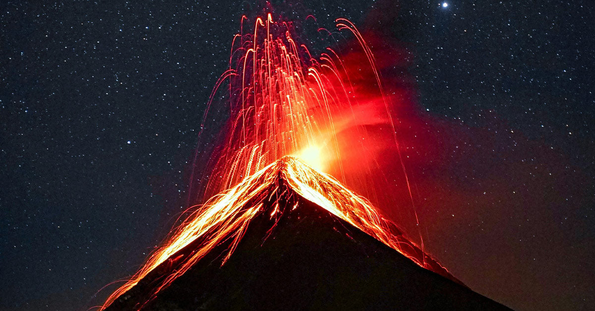
As magma drained from the chamber below, the structure of the volcano could no longer support its own weight. Circular fractures formed, and the summit collapsed inward. Pyroclastic flows — fast-moving avalanches of superheated gas and rock — swept down its flanks.
The eruption expelled an estimated 176 cubic kilometers (42 cubic miles) of material. The collapse reduced Mazama’s height by about 1,600 meters (5,250 feet), leaving behind a caldera roughly 8 by 10 kilometers wide and over 1,200 meters deep.
In the years that followed, rain and snowmelt gradually filled the basin, forming Crater Lake.

The eruption may have temporarily cooled Northern Hemisphere temperatures by up to 0.7°C (1.3°F) for several years — a measurable global climate impact.
Mazama was not simply an eruption. It was a transformation of the landscape on a continental scale.
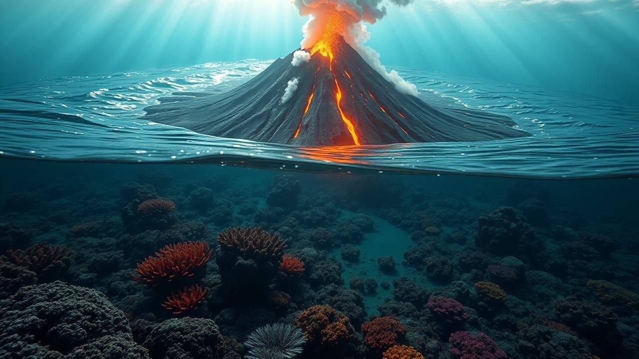
Now shift your attention roughly 480 kilometers (298 miles) west of Oregon’s coast. Nearly 1,400 meters (4,600 feet) beneath the Pacific Ocean lies Axial Seamount — the most active submarine volcano in the Northeast Pacific.
Unlike Mount Mazama, Axial sits on the Juan de Fuca Ridge, a mid-ocean ridge where tectonic plates move apart rather than collide. This distinction is critical.

Mazama was a stratovolcano fueled by silica-rich, explosive rhyolitic magma. Axial is a shield volcano fed by basaltic magma — thinner, more fluid, and far less explosive.
If Mazama’s magma was like honey under pressure, Axial’s is more like ketchup: it flows easily and releases gas gradually.
That difference changes everything.
Axial Seamount does have a caldera — about 3 by 8 kilometers wide — formed by past collapses of its magma chamber. But the processes are fundamentally different from those that destroyed Mount Mazama.

Axial has erupted in 1998, 2011, and 2015. Scientists closely monitor it through a sophisticated underwater observatory known as the Regional Cabled Array. Instruments measure seismic activity, seafloor deformation, and magma movement in real time.
Since the 2015 eruption, the seafloor inside Axial’s caldera has been inflating again as magma accumulates below. By late 2025, scientists observed that the seafloor had risen approximately 10 centimeters (4 inches) compared to pre-2015 levels. They estimate roughly 20 additional centimeters (8 inches) of uplift may precede the next eruption.
In August 2025 alone, the volcano recorded up to 2,000 small earthquakes in a single day — a sign of active magma movement.
Yet despite this activity, experts agree: Axial will not “collapse like Mazama.”
Why?
Because its basaltic magma erupts gently, typically producing lava flows that reshape the ocean floor rather than explosive plinian eruptions. The immense water pressure above the volcano also suppresses violent explosions.
Even if Axial erupts tomorrow, scientists expect no tsunami and no impact on coastal communities. The eruption would likely remain entirely underwater, gradually spreading new lava across the seafloor.
In fact, researchers hope to livestream the next eruption — a scientific milestone made possible by constant monitoring.

Mount Mazama formed in a subduction zone, where one tectonic plate dives beneath another. This process generates volatile-rich, silica-heavy magma prone to explosive eruptions.
Axial Seamount, by contrast, forms at a spreading center where plates pull apart. The magma here is basaltic, low in silica, and far less explosive.
Both volcanoes have calderas. Both involve magma chambers and collapse mechanisms. But the chemistry and tectonic environments make their hazards dramatically different.
Mazama reshaped a mountain and altered climate patterns.
Axial reshapes the seafloor quietly beneath the ocean.
The story of Mount Mazama reminds us how quickly a volcano can transform a landscape. The story of Axial Seamount demonstrates how far science has advanced.
Today, Oregon is home not only to one of North America’s most dramatic volcanic scars but also to the most closely monitored submarine volcano on Earth.
Rather than fear, Axial represents opportunity — a chance to observe volcanic processes in real time and refine eruption forecasting.

Mount Mazama teaches us about catastrophic potential.
Axial teaches us about vigilance.
And together, they reveal the extraordinary forces constantly shaping the planet beneath our feet.


