Outer Banks Collapse Zone: 31 Homes Lost as the Atlantic Advances
The Outer Banks of North Carolina have long been defined by wind, waves, and shifting sands. But in early February 2026, the dynamic nature of this barrier island chain turned catastrophic. Over the course of a single storm cycle on February 1st and 2nd, four oceanfront homes in Buxton collapsed into the Atlantic Ocean.
In less than 48 hours, full residential structures—once marketed as dream beach investments—were reduced to splintered lumber, twisted metal, and scattered debris stretching for miles along Cape Hatteras National Seashore.
Those four homes brought the total number of houses lost to erosion along these beaches to 31 since 2020. Eighteen of those collapses have occurred in Buxton alone. And officials warn the pattern is accelerating.

Buxton sits on Hatteras Island, a narrow barrier island famous for the Cape Hatteras Lighthouse and its miles of pristine shoreline. But barrier islands are inherently temporary landforms. They shift, migrate, and reshape under the constant force of wind and waves.
For decades, erosion here followed relatively predictable patterns. Shorelines moved gradually. Beach nourishment projects—where sand is dredged and pumped onto eroding beaches—offered temporary relief.
Homes built in the 1980s and 1990s once stood hundreds of feet from the ocean.
Today, many of those same structures sit directly at the surf line.
Epic%20Shutter%20Photography___.jpg)
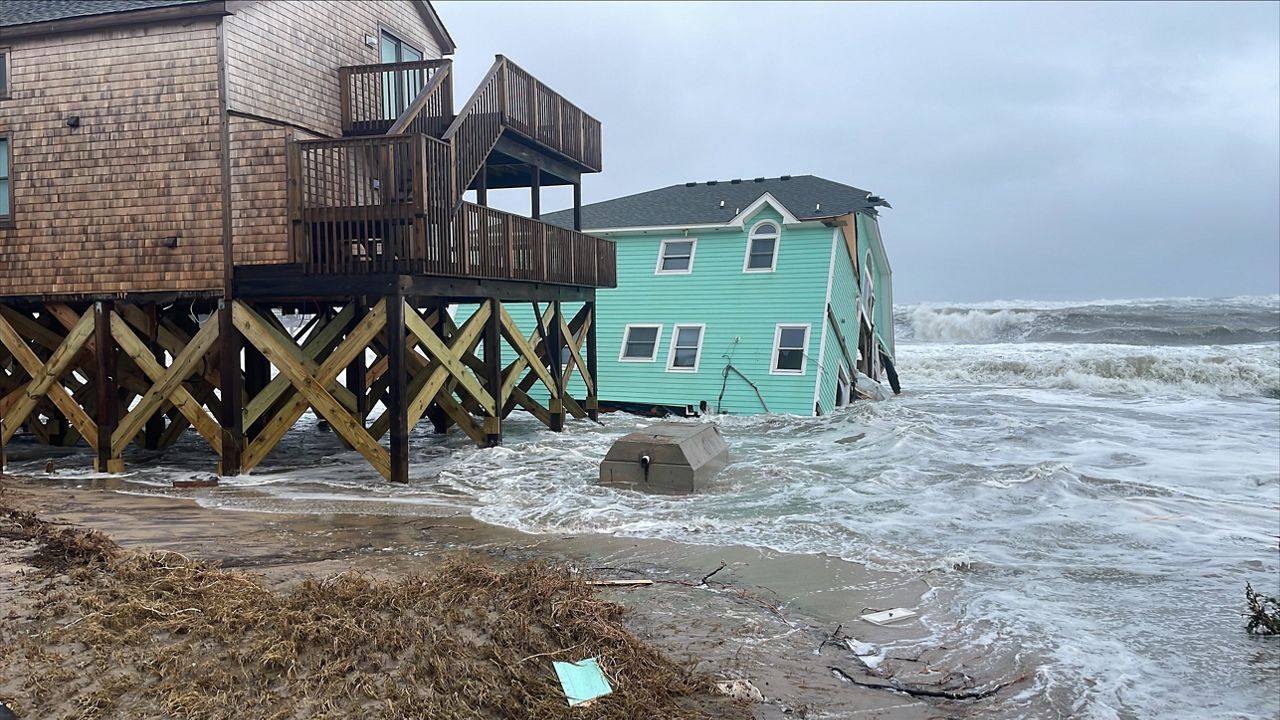
The February storm overwhelmed dunes and pushed waves deep inland. When the surge receded, the sand supporting several homes had vanished. Foundations were undermined. Walls fractured.
Entire buildings tilted and slid into the water, breaking apart as waves pounded them into debris fields.
The National Park Service confirmed the collapses within hours and immediately closed sections of beach near access ramps 43 and 44 due to safety hazards.
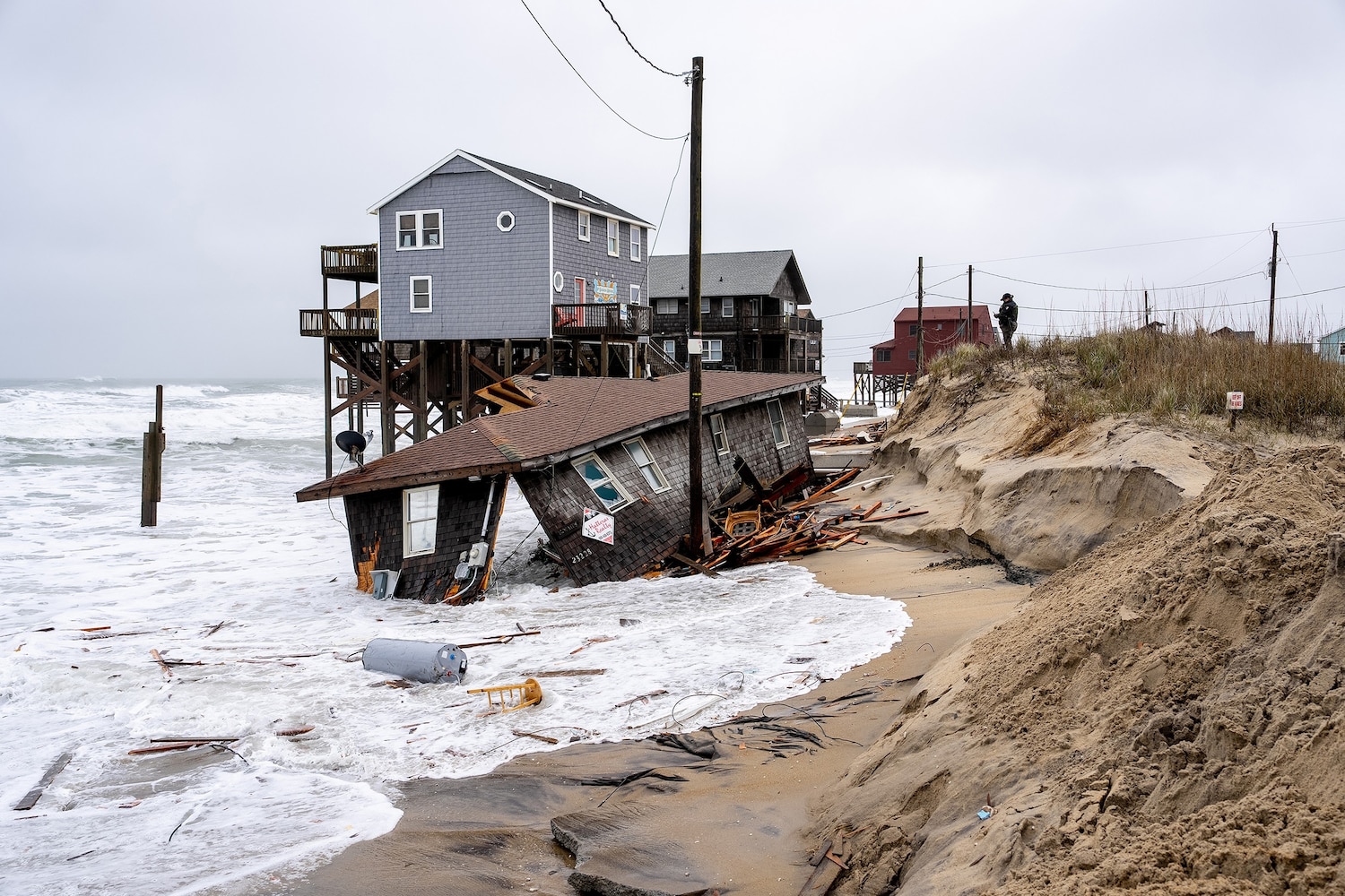
The wreckage left behind resembles a disaster zone more than a vacation destination. Twenty-foot wooden beams protrude from the sand. Nails and shards of metal lie hidden beneath shifting drifts. Sections of roofing and cabinetry are scattered across miles of shoreline.
Cleanup crews are scheduled to begin debris removal on February 25th, with property owners instructed to stage materials along Old Lighthouse Road. Officials estimate the process will take one to two days.
But clearing debris addresses only the aftermath—not the cause.

North Carolina Highway 12, the only road connecting communities on Hatteras Island, faced multiple closures during the storm due to ocean overwash flooding the pavement. When Highway 12 shuts down, entire communities become isolated. Emergency services are delayed. Supply chains are disrupted. Tourism stalls.
Although recent closures lasted hours rather than days, they underscored how fragile infrastructure has become. Over the years, Highway 12 has been relocated, elevated, and reinforced repeatedly as erosion eats away at the island’s edges.
Each repair buys time. None offer permanence.
The collapse zone in Buxton is part of a broader trend along the Outer Banks. Rodanthe, just north of Buxton, experienced similar dramatic collapses in 2022, when three homes fell into the ocean during a single storm. Those images went viral, serving as an early warning of what was to come.
Now the pattern appears to be migrating south.
Sea level rise is compounding the crisis. Along the North Carolina coast, sea levels are rising faster than the global average due to a combination of warming oceans and regional land subsidence. Higher baseline water levels allow storm surge and wave action to penetrate farther inland, accelerating erosion.
The result is a coastline retreating faster than many predictive models anticipated.

The implications extend far beyond the collapsed structures themselves. Tourism is the economic backbone of the Outer Banks. When beaches close due to debris hazards, visitors cancel trips. When Highway 12 becomes unreliable, rental bookings decline.
Early signs suggest the 2026 tourist season may suffer. Rental agencies report increased inquiries from concerned vacationers asking whether beaches are safe and accessible.
Meanwhile, property values in erosion-prone zones are falling sharply. Homes near the shifting shoreline are increasingly difficult to sell. Insurance premiums have surged, and some providers have stopped offering policies within certain high-risk areas altogether.
Homeowners now face wrenching decisions: invest in costly mitigation measures, sell at steep losses, or walk away entirely.

The accelerating collapses raise fundamental questions about the future of development on barrier islands. Should homes continue to be built—or rebuilt—on land that is actively disappearing?
Should public funds support repeated beach nourishment projects that protect private property? How long can infrastructure like Highway 12 realistically be maintained?
The National Park Service can close beaches and require debris removal, but it has limited authority over private rebuilding decisions. Dare County officials can track erosion and coordinate responses. Neither can stop the ocean.
Since 2020, 31 homes have been claimed by the Atlantic along Cape Hatteras National Seashore. Each number represents more than lumber and drywall. These were family gathering places, retirement investments, and symbols of permanence on a coastline that has never promised stability.

Cleanup crews will remove debris from February’s collapse. Beaches will reopen. Visitors will return.
But the ocean continues its advance.
The Outer Banks were formed by movement. Now that movement is accelerating, reshaping not just the shoreline—but the future of coastal living in North Carolina.
The only certainty is that the next storm will come.


