Terror in New Zealand: A Roaring Landslide Devours Mount Maunganui, Vehicles & Homes Vanish in Seconds
In the early hours of a morning that began like any other along the coast of New Zealand, something shifted beneath Mount Maunganui.
It did not begin with a dramatic explosion.
There was no towering column of ash splitting the sky, no lava streaming visibly toward the sea.
What witnesses describe instead is subtler—and perhaps more unsettling.
A low vibration.
A sound like distant thunder trapped underground.
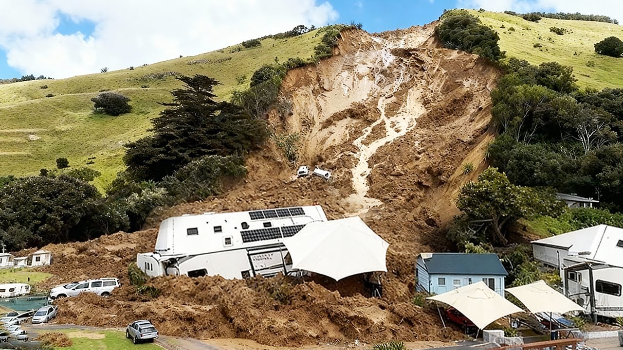
Then a section of the mountainside simply gave way.
Within seconds, earth and rock cascaded downward, swallowing parked vehicles and crushing parts of residential properties at the base of the slope.
Surveillance footage now circulating online shows a pale cloud rising before the collapse, almost like steam venting from unseen cracks.
Officials have urged caution in interpreting these images.
They have used words such as “extreme weather,” “soil saturation,” and “geotechnical instability.
” They have not used the word eruption.
Yet residents continue to repeat the same detail: the mountain did not feel stable long before the slide.
Some describe warmth radiating faintly from patches of rock days earlier.
Others recall a sharp, mineral scent in the air the night before the collapse.
One homeowner, who asked not to be named, said the windows rattled briefly just minutes before the landslide, though no official seismic alert was issued.
The shaking was short, localized, and—according to authorities—insufficient to classify as a tremor of concern.
Mount Maunganui, known affectionately as “The Mount,” is not widely regarded as an active volcanic threat in the way other peaks across the Pacific are.
It stands as a beloved landmark, a destination for hikers and tourists, a symbol printed on postcards and travel brochures.
The idea that it might conceal pressure beneath its surface feels, to many locals, improbable.
And yet, geological history across this region is rarely straightforward.
New Zealand sits along the volatile boundary of tectonic plates.
Dormancy does not always mean extinction.
The landslide struck without formal warning.
Emergency services responded swiftly, cordoning off affected areas and evacuating several households as a precaution.
Miraculously, initial reports indicate no confirmed fatalities, though injuries have been treated and property damage is extensive.
Crushed vehicles remain partially buried in compacted mud and shattered stone.
Sections of fencing and roofing lie twisted under debris.
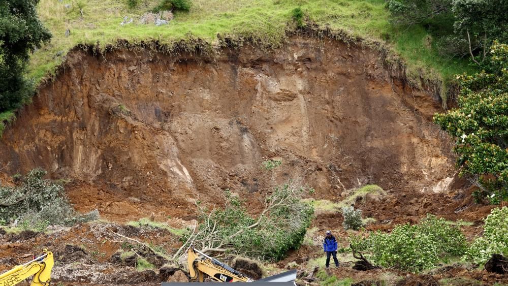
Drone footage reveals a raw scar carved into the hillside, exposing layers of earth that appear fractured rather than smoothly eroded.
Authorities have emphasized that heavy rainfall in recent days likely destabilized the slope.
Meteorological data does confirm above-average precipitation leading up to the incident.
But online speculation has not been so restrained.
Clips slowed down frame-by-frame appear to show a brief upward burst of dust or vapor seconds before the slope failure.
Some users claim the plume resembles a minor venting event.
Others argue it is merely compressed air and soil displacement escaping as the ground sheared away.
Geologists dispatched to ᴀssess the site are conducting thermal imaging and gas sampling as part of standard hazard evaluation.
Official statements describe these measures as precautionary.
Still, the decision to measure gas emissions has fueled debate.
If this were solely a rainfall-triggered landslide, critics ask, why test for volcanic gases at all? Experts counter that in a geologically complex region, ruling out contributory factors is routine protocol, not evidence of concealment.
The tension between reᴀssurance and uncertainty has become as visible as the debris itself.
Press conferences remain measured.
Terms such as “multifactorial” and “ongoing ᴀssessment” recur frequently.
No authority has confirmed eruptive activity.
None have categorically dismissed it either.
That ambiguity leaves space—wide space—for interpretation.
Historically, New Zealand has experienced abrupt geological events that defied initial ᴀssumptions.
From sudden hydrothermal bursts to unexpected ground deformation episodes elsewhere in the country, the land has demonstrated that calm surfaces can mask intricate subsurface dynamics.
Mount Maunganui has not been ᴀssociated with recent volcanic unrest, but absence of recent activity is not synonymous with impossibility.
Geological systems evolve over centuries, sometimes reactivating in ways that surprise even seasoned observers.
Residents describe an atmosphere that feels different now.
The walking tracks remain closed.
Warning tape flutters where families once gathered for sunrise views.
Some locals report hearing intermittent cracking sounds from the hillside in the days following the slide, though officials attribute these to settling debris.
Structural engineers are evaluating slope stability, installing monitoring equipment to detect further movement.
The language remains cautious, but the hardware suggests vigilance.
Insurance ᴀssessors have begun cataloging losses.
Property owners face weeks—perhaps months—of uncertainty.
Beneath practical concerns, however, lingers a quieter unease.
If this was solely an extreme weather event, then it fits within an increasingly familiar global pattern of climate-amplified disasters.
If it involved geothermal or volcanic destabilization, even minimally, then the narrative shifts.
It becomes not just a weather story, but a geological one.

Scientists interviewed have stressed that minor geothermal activity does not necessarily equate to imminent eruption.
The earth can vent small amounts of gas without escalating.
Thermal anomalies can arise from friction and pressure as slopes shift.
Yet the coincidence of reported warmth, subtle vibration, and sudden structural failure has created a narrative that resists tidy closure.
Data from regional monitoring stations has not shown significant seismic escalation preceding the event.
That fact is central to official reᴀssurances.
However, microseismic movements below certain thresholds may go undetected or unpublicized in real time.
Whether such signals occurred remains under analysis.
Agencies insist transparency will guide public updates.
Skeptics argue that transparency often trails behind interpretation.
Drone surveys conducted in the aftermath show irregular fracture lines along the upper section of the scar.
Some appear fresh, jagged, and angular.
Others look weathered, as if tension had been building gradually.
Geotechnical specialists caution against drawing conclusions from surface imagery alone.
Subsurface imaging is required to understand the depth of failure.
That work is ongoing.
Social media has amplified both fear and fascination.
Side-by-side comparisons of archived images and current drone footage circulate widely.
Amateur analysts highlight color changes in rock strata, speculating about heat exposure.
Professional volcanologists respond with measured threads explaining how oxidation and moisture can alter hue without thermal cause.
The digital debate grows louder than the mountain itself.
In the meantime, daily life at the base of Mount Maunganui has narrowed.
Access roads remain partially restricted.
Residents retrieve belongings under supervision.
Tour operators field cancellations.
The economic ripple spreads quietly outward.
Local officials balance two imperatives: prevent panic and prevent complacency.
One detail remains unresolved in public discourse: the timing.
Several witnesses independently reported sensing something unusual in the air hours before the slide—an acrid scent, faint but persistent.
Environmental testing results have not yet been released.
Whether those perceptions were influenced by hindsight is impossible to determine.
Human memory, particularly under stress, is notoriously malleable.
What is certain is the physical transformation of the landscape.
Where there was once a continuous slope now lies a gouged cavity.

Vegetation has been stripped away.
The geometry of the mountain has altered.
Even if investigations conclude that rainfall alone triggered the collapse, the image of that pale plume rising seconds before impact will likely endure.
Mountains are often perceived as symbols of permanence.
Their silhouettes anchor skylines and idenтιтies.
When they shift abruptly, the psychological effect can rival the physical damage.
In New Zealand, where the relationship between land and life is deeply intertwined, such events resonate beyond immediate impact zones.
Officials have pledged a comprehensive report once analyses conclude.
Until then, language will remain provisional.
Was this an isolated convergence of rain and gravity? Or did subtle geothermal unrest tip an already fragile slope into catastrophe? The difference matters—not just scientifically, but culturally.
For now, Mount Maunganui stands quieter than before, its trails empty, its flanks under scrutiny.
Monitoring equipment hums softly where hikers once paused for pH๏τographs.
The ground appears still.
Yet the memory of that morning—of vibration, of a rising cloud, of earth accelerating downward—lingers.
Whether this episode will be remembered as a straightforward landslide intensified by weather patterns, or as the first sign of deeper geological stirring, depends on findings not yet finalized.
In a landscape shaped by tectonic forces, certainty is rarely immediate.
What remains is the undeniable image of stability disrupted in seconds—and the uneasy recognition that even familiar landmarks may conceal forces not yet fully understood.


